
How a National Survey Became a National Information System
The ancient walls still enclosed Derry, but they no longer contained the city in which Elizabeth Hester Boyd had grown up. [i] Had she returned to the city of her childhood, she would have recognised its streets but found new suburbs spreading beyond its gates. The railway had arrived, Carlisle Bridge replaced the old crossing of the Foyle in 1863, quays expanded, and industry was flourishing. The population exploded and would more than double by the end of the century. If Thomas Colby had returned with his wife, he would have discovered a city changing quicker than the map could record. It is a simple truth that the moment a map is completed, it begins to go out of date. [ii]
The challenge of keeping pace with change extended beyond Derry. The six-inch survey of Ireland had been completed by 1846 and was one of the nineteenth century’s most ambitious scientific and cartographic achievements. Alongside it were detailed town plans at five feet to the mile, prepared in support of Griffith’s Valuation and urban administration. Even as the maps were published, new railways crossed fields, roads were improved, houses were built and demolished, rivers were straightened, and bogland reclaimed. Having solved the problem of mapping Ireland, the challenge became keeping the national map up to date.
The maps had become indispensable. Engraved, published and made available to the public at an affordable price, [iii] they quickly found uses far beyond the valuation of land for taxation. Government departments, estate owners and local administrators increasingly relied upon them. They defined townland boundaries, allowing objections to be resolved before Griffith’s Valuation was completed. They supported estate management, parliamentary business and public administration. They recorded roads, bridges, rivers, canals, harbours and other features essential to the country’s growing infrastructure. They provided the base map for geological, mineral and statistical surveys. In Colby’s words, they supplied information “… important in every branch of domestic and political economy connected with improvement.”
Such success created a new problem. The more widely they were used, the more damaging it was when they no longer reflected the landscape. A railway omitted, a new road unrecorded or a changed boundary could affect taxation, administration, engineering and land ownership alike. Accuracy and currency had become a practical necessity.
Colby had anticipated this problem as early as 1827, when he argued for the “perpetuation of the Survey”, so that “all subsequent alterations and improvements taking place in the country may be inserted and the future necessity of resurvey prevented.” [iv]
Revision began in County Donegal in 1845, moving through Londonderry, Tyrone, Fermanagh, Antrim and Down, with survey methods adapted to the quality of the original mapping in each county. The programme was later extended to the rest of Ireland. [v] It was driven as much by administrative need as by geographic logic. The government eventually authorised systematic revision across the whole country, formally recognising that the national map had become an essential administrative record as well as a scientific survey, and that it needed to be updated regularly.
True to his character, Colby was unwilling to sacrifice scientific discipline for convenience, and he insisted on applying his system to the revision of the maps. When early revisers proposed simply amending existing sheets, he insisted that revision should be “entirely performed in the same way the original was done.” Accuracy, once established, could only be preserved by maintaining the same rigorous standards that had created it. For many years, revision resembled the original survey in miniature. Surveyors returned repeatedly, checking, measuring and recording change. Gradually, their methods evolved. Instead of complete resurveys, revisers increasingly carried translucent traces printed from the existing maps, fitting new detail to the original by means of graphic survey methods, using optical alignments, taped distances and occasional chaining. New roads, buildings, drains and boundaries were inserted; obsolete features removed. Beneath each successive edition, much of the original survey remained intact.
Revision preserved accuracy and currency, but it could not overcome the limitations of scale. Remarkable though it remained, the six-inch scale had been designed for a different Ireland. As the nineteenth century progressed, land ownership became increasingly fragmented, estates changed hands, and the demands of valuation, conveyancing and land purchase grew ever more exacting. The six-inch scale could no longer depict all the detail that was required.
The solution was to extend the Survey’s framework and in 1887, the Treasury authorised a national twenty-five-inch survey of Ireland. At this scale, individual field boundaries, walls, outbuildings and many minor features could be shown systematically across almost the entire country. [vi]
This was far more than an enlargement of existing maps. The greater scale demanded greater precision. The original primary triangulation remained in place, supplemented by an entirely new secondary and tertiary triangulation network, established to a higher standard of accuracy with modern instrumentation. Much of the landscape was re-chained and re-surveyed. Whilst the original six-inch maps continued in use, all future revisions would depend on the more detailed twenty-five-inch sheets.
Associated with the new survey came extensive re-levelling with new benchmarks. This new work exposed discrepancies within parts of the earlier height network and revealed a broader reality: what had once represented the highest attainable precision no longer fully satisfied contemporary scientific expectations. [vii]
By 1914, the twenty-five-inch map was substantially complete, and a process of revision was in place that echoed Colby’s original idea of perpetuation. The maps expanded outward into multiple scales and purposes. One-inch, half-inch and quarter-inch maps, derived from the larger-scale surveys, provided cartographic coverage for travellers, administrators, engineers, and the public. [x] Ninety years after the survey of Ireland had begun, Ireland had been completely mapped at a variety of scales. Many different representations of the country could be produced from the same survey, each designed for a particular purpose.
The map had become reproducible infrastructure. In doing so, the Survey fulfilled Colby’s original vision more completely than even he could have imagined. What had begun as an imperial project of measurement turned to fiscal and administrative purposes. By the middle of the nineteenth century, the Survey had become a recognisable institution, [viii] and by the end of the century, its maps became part of the legal infrastructure required for the registration of title. [ix]
The Ordnance Survey, as it had now become, did not simply preserve earlier work; it would continuously renew and improve it. Each generation inherited a system created by its predecessors and adapted it to new requirements, new technologies, and higher standards of accuracy.
This continuity became one of the Survey’s greatest strengths. Benchmarks cut decades earlier continued to support new measurements. Older triangulation stations remained the foundation of fresh observations. Maps were revised, redrawn, photographically reproduced, and updated again while the underlying survey framework endured.
The Ghosts of Mountjoy had become guardians of this continuity. Their marks remained in the bridges, churches, gateposts, and stone walls and their lines survived beneath revised sheets, new editions, and later technologies. Their influence would be felt even into the twentieth century when satellites replaced the chain, and much of the modern geospatial infrastructure would still rest upon systems first established by them during the nineteenth century.
The map was no longer just a representation of the landscape, it had become a way of organising it and managing it, part of the authoritative spatial infrastructure upon which modern government increasingly depended. As Colby had foreseen, the task of the Ordnance Survey had become one of “perpetuating the survey”, revising and updating the maps to reflect the growing towns, changing roads and railways, growing forests, streams and changing coastlines of the country. The Ordnance Survey no longer measured the landscape merely to produce maps; it increasingly maintained a national framework upon which others depended.
Then the Great War transformed everything, utterly.
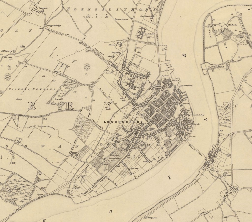
Surveyed: 1830, Engraved: 1831, Printed: 1837
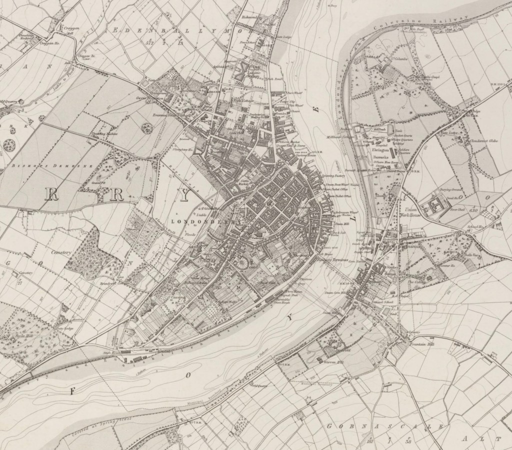
Revised: 1853, Printed: 1863
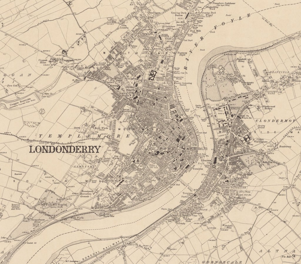
Revised: 1904 to 1905, Published: 1907
Footnotes
Header Image is AI generated
Maps reproduced with the permission of the National Library of Scotland, CC-BY (NLS) https://maps.nls.uk/
[i] Elizabeth Hester Boyd was the daughter of Archibald Boyd, Treasurer of the City of Londonderry.
[ii] For a more detailed study of the growth and development of Derry-Londonderry see Thomas, Avril The Irish Historic Towns Atlas (IHTA), no. 15, Derry~Londonderry, Royal Irish Academy, 2005.
[iii] Maps were engraved and multiple copies published at a cheap rate to repay part of their cost.
[iv] “Lt Colby’s report to Sir Henry Hardinge KCB on the present state and progress of the Irish Survey”, February 15th, 1827. NAI, OS/1/2
[v] The first systematic revision of the Irish six-inch maps began in County Donegal in 1845, following Treasury authority in 1844 to complete and revise the mapping of the northern counties. Captain Leach initially proposed updating existing map impressions directly in the field, but Thomas Colby rejected this approach, insisting that revision be carried out “entirely performed in the same way the original was done.” Subsequent revisions varied by county according to the quality of the original survey: Londonderry required almost complete resurvey from the trigonometrical framework, while Fermanagh, Antrim and Down were eventually surveyed afresh. W. A. Seymour (ed.), A History of the Ordnance Survey (Folkestone: Dawson, 1980), pp. 148–150.
[vi] The 1:2500 map is commonly known as the twenty-five inch map, because on the map, 25.344 inches equals one mile. Areas of extensive mountain and bog were not surveyed at the new scale.
[vii] Initial spirit levelling was carried out during the 1840s and was based on the low water mark of the spring tide at Poolbeg Lighthouse in Dublin, on 8th April 1837. This network of spirit levelled lines was not rigorously adjusted at the time. The work was repeated in the 1890s, and adjusted to certain points in the original network, known as ‘Key Points’, whose heights as measured from Poolbeg were accepted as ‘truth’. In fact, there was a measurable discrepancy of 0.8 feet between the 1840 and 1890 schemes, and a series of secondary levelling lines established further benchmarks in the 1900s. As we have seen in the earlier blog, the reference surface itself—sea level—remained open to debate and the Survey retained the Poolbeg datum.
[viii] An organisation that had become known as the Ordnance Survey is mentioned in various Acts of Parliament transferring its functions between Departments and Ministries, such as following the dissolution of the Board of Ordnance into the War Office in 1855 and then in 1870, part of the Department of Agriculture. It continued to be managed by Royal Engineers.
[ix] The Local Registration of Title (Ireland) Act 1891 created a system in which the title, rather than simply the deed, was registered and the state guaranteed the ownership recorded in the register. Ordnance Survey maps, already widely available and widely trusted, became an integral part of the legal system of property registration, providing the authoritative map on which ownership could be identified, recorded and guaranteed by the state.
[x] There are several books that comprehensively cover the story of the Ordnance Survey’s small scale cartographic products, including:
- Andrews, J.H., A Paper Landscape: The Ordnance Survey in Nineteenth-Century Ireland. Oxford, 1975.
- Hellyer R. and Oliver R., Ordnance Survey Small Scale Maps Charles Close Society, 2023
By subscribing, you will be notified of new posts.

Response
[…] could never remain complete—as the landscape changed, the map had to change with it. Systematic revision established the principle that geographical information requires continual maintenance, […]
LikeLike