This appendix expands upon the themes introduced in “The Sea Was Not Level” for readers interested in the technical and historical development of Ireland’s first national vertical datum. [i]
When the Ordnance Survey began measuring heights during the 1820s and 1830s, the obvious reference was the sea. At first, surveyors commonly adopted a local tidal reference datum, usually low water, from which the heights of nearby trigonometrical stations could be determined. The Earth was assumed to be sufficiently regular for such local datums to be entirely adequate. Little was yet understood about regional variations in sea level, the influence of gravity, or the complex behaviour of currents and tides around an irregular coastline.
As the trigonometric survey expanded across Ireland, connections were made between neighbouring coastal points and were found to differ by as much as twelve feet. [ii] So an alternative method was adopted in which selected trigonometrical stations were connected by lines of observation running from coast to coast, east to west, each tied back to the sea at either end. The results improved consistency, but discrepancies remained. [iii] Although such discrepancies were tolerable for topographic mapping, they were increasingly problematic for scientific and engineering purposes.
These discrepancies could not entirely be explained by the method of determining height by observing vertical angles between stations. The observations of low water mark around the coast may well have reinforced what the surveyors increasingly suspected: the sea stood at different levels in different places. Whilst no contemporary record of such observations remains, the reference point at Poolbeg was likely one of these points. It was established by measurements dated on 8 April 1837, before the adoption of levelling in 1839 and before Airy’s later work concluded. [iv]
Around this time, engineers were demanding greater practical accuracy. Planning for the railways, roads, drainage and engineering works required reliable consistent gradients and continuous levels over long distances.
At the same time, spirit levelling was found to be a precise means of measuring height differences between survey points. It had first been used in the north of Ireland in 1837, but it was not until the British Association’s Axmouth–Portishead levelling experiment of 1837–38 that the accuracy achievable through spirit levelling was established. Colby decided that Ireland would be the first large-scale application of this method. [v]
Work then began on an extensive network of levelling lines across the country. This was carried out along Irish roads and canals under Lieutenants G. B. Downes and John Cameron between 1839 and 1843. The levelling parties advanced slowly across the country, cutting benchmarks along the way, their progress measured in yards rather than miles. Every observation was checked and repeated. Lines were levelled out and back again, or around loops, to test their accuracy. The work was laborious, but it produced something new: a reliable framework of heights extending across Ireland. [vi]
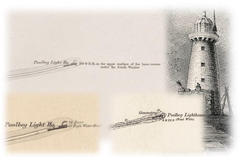
To avoid the problem of multiple reference levels, a single point was chosen as the national datum to which all heights would be referred. The coastal station at Poolbeg Lighthouse at the mouth of the River Liffey was chosen. The exact reason for its selection remains unclear. There, a permanent mark had been cut into the masonry beneath the south window of the lighthouse and the distance between the mark and the level of the sea at low water of a spring tide was measured on 8 April 1837 as 20.900 ft. From this apparently simple measurement, every subsequent height in Ireland would ultimately be referred.
This datum should not be confused with mean sea level. Poolbeg Datum was defined by the measured relationship between the permanent mark at Poolbeg Lighthouse and the level of low water observed on a single day in 1837. Mean sea level, by contrast, is the average height of the sea over a prolonged period of observation, making it a more stable and scientifically robust vertical reference. Low water was adopted because it lay below almost all land, ensuring that every measured height was positive. Poolbeg was subsequently selected in 1841 as the Ordnance Datum Dublin (ODD). [vii]
Meanwhile, the scientific understanding of the sea itself was changing, and the question of sea level continued to occupy Thomas Colby’s attention. Until now, the Ordnance Survey had been using low water of spring tides as its reference sea level, but as awareness of the complexity of the tides, the effects of wind and atmospheric pressure on sea level, and the effects of ocean currents, the question remained whether low water really the best reference level?
Working with the Astronomer Royal, George Airy, Colby initiated an extensive programme of tidal observations at twenty-two stations around the coast to determine which was the best sea level. Day and night, observations were made every ten minutes over three months during the summer of 1842. More than 200,000 readings were taken, then sorted, averaged and subsequently analysed. [viii]
Analysis of the observations showed that tidal levels varied dramatically around Ireland, in some cases by as much as nine feet, whereas mean sea level varied much less, by about 2½ feet. The results reinforced the scientific case for mean sea level as the preferred vertical reference level.
By the time Airy’s conclusions had been reached, the Irish levelling network had already been completed, and thousands of heights had been engraved on the published six-inch ordnance maps of Ireland. Recomputing the entire network and revising the mapping to a new datum would have represented a formidable and costly undertaking. Instead, the Survey continued to use the Poolbeg datum, despite the growing scientific appreciation that low water did not provide the ideal geodetic reference. [ix] Poolbeg would remain Ireland’s national vertical datum for more than a century, until the 1950s.
Looking back, it is tempting to see the choice of Poolbeg as a simple technical decision. It was anything but. It emerged at a time when ideas about tides, gravity and the shape of the Earth were themselves evolving. The Irish Survey solved the practical problem of creating a national height network before the science of sea level was fully understood. Although the surviving published record still leaves important questions unanswered about the original relationship between the Poolbeg datum and the nature of sea level around the coasts of Ireland, perhaps that is fitting. It was a survey that transformed our understanding of the Irish landscape, and yet it still invites us to explore its history.
Footnotes
The header image shows how the Poolbeg datum was depicted on early Ordnance Survey maps. The lower left is the first edition of Dublin sheet 19, Ordnance Survey Six-inch to the mile map, surveyed 1837, printed 1843; the top right is the same sheet 19, as corrected 1843, printed 1863; the lower right is the same sheet 19, revised 1907 to 1908, published 1912. Map images courtesy of the National Library of Scotland, Reuse by CC_BY (NLS). See https://maps.nls.uk/
[i] This Appendix is based on several sources:
- Brigadier K M Papworth, The Ordnance Survey of Northern Ireland, read at the Institute of Land Surveying and Mining, 11th December 1958;
- Captain W C Carlielle, Ordnance Survey Methods and Processes, Talk to Belfast Surveyors Institute, undated but probably in the late 1920s;
- Col. W R Taylor, The Ordnance Survey of Northern Ireland: An Outline of its History and Present Mapping Tasks”, The Cartographic Journal, 6:2 87-91;
- “Carthographer”, [stet] Draggers of the Rope, Engineers Journal, Ireland, July 1955.
- Seymour, W. A. (ed.), A History of the Ordnance Survey (Folkestone: Dawson, 1980).
For an interesting article about the history of sea-level see Our Very Strange Search for “Sea Level” by Brooke Jarvis, The New Yorker Magazine, 19 August 2024.
Also see Dixon, F. E. Irish Mean Sea Level. 1949, which describes the evolution of the determination of sea level around the Irish coasts.
[ii] The discrepancies are described further in Seymour, A History of the Ordnance Survey, 1980 as well as the several sources cited at FN i above, The alternative methods tried are also described by Portlock, in his Memoir of the Life of Major-General Colby, 1869, p 209-315.
[iii] This method is described by Portlock, in his Memoir of the Life of Major-General Colby, 1869, p 209-315.
[iv] David T. Pugh, A. G. P. Shaw, L. J. Bradley, and D. E. Smith, Mean Sea Level and Tidal Change in Ireland Since 1842: A Case Study of Cork, Ocean Science 17 (2021): 1623–1646.
[v] Close, The Early Years of the Ordnance Survey,1926.
[vi] Cameron, John, Abstracts of Principal Lines of Spirit Levelling in Ireland Carried on During the Years 1839 to 1843 under the Direction of the Late Major-General Colby. Published by Order of the Master-General and Board of Ordnance. London: Longman, Brown, Green & Longmans, 1855.
[vii] Andrews, A Paper Landscape, p111
[viii] Airy, George Biddell, On the Laws of the Tides on the Coast of Ireland, as inferred from an extensive series of observations made in connexion with the Ordnance Survey of Ireland, Proceedings of the Royal Society of London, 5 (1843–1849), 539–540.
[ix] England, where levelling had not yet advanced, adopted mean sea level, initially at Liverpool and later at Newlyn in Cornwall.
By subscribing, you will be notified of new posts.

Response
[…] of secondary levelling lines established further benchmarks in the 1900s. As we have seen in the earlier blog, the reference surface itself—sea level—remained open to debate and the Survey retained the […]
LikeLike