Benchmarks, Folklore and the Measurement of Height
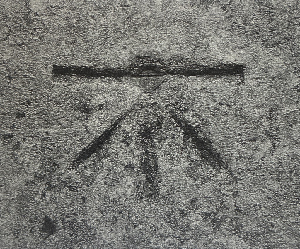
Across Ireland, a curious symbol appears on walls, buildings, bridges, and churches. Most people walk past them without noticing. Those who do rarely know what they mean. Each consists of a horizontal line cut into the stone, with three smaller lines beneath forming an arrow. It resembles a crow’s footprint, and thousands survive across Ireland. Some are worn almost smooth by weather and time; others remain as sharp as the day they were carved. Scattered across the landscape, they resemble tiny wrinkles on the face of an ancient land, traces of past achievement still visible two centuries later. [i]
These small carvings are among the most enduring traces left by the nineteenth-century Ordnance Survey. Known as crow’s feet or sapper’s marks, they were carved in place by the Royal Engineers, and each marked a measured height above sea level. [ii] The soldiers have long gone, but they have left their mark on a land already rich in folklore, memory and story.
Local people often watched the sappers at work. A mark would first be painted on the wall or stone before a stonemason’s hammer and chisel cut it permanently into the rock. A mother or grandmother might bring tea while the soldiers explained why it mattered. It recorded a precise height above the sea and helped surveyors understand the rise and fall of the landscape.
To the villagers, it was simply a mark on a wall. To Thomas Colby, it formed part of a much larger ambition. Height was one of the things he believed the survey should record. By recording elevations throughout Ireland, he hoped to create a general register of the country’s altitudes and eventually show them on the six-inch maps. [iii] The resulting survey would become a model of Ireland itself, revealing its shape, supporting engineering and improvement.
The small crow’s foot cut into a bridge or church wall was therefore part of a much larger objective: to measure Ireland not only across its surface, but also up and down.
The soldiers explained how, one day, men would return and look for the mark. They stressed its importance and the care it required. It must not be damaged or removed. The request was often treated with surprising seriousness, and in some places a local farmer or cottager took on the role of unofficial guardian of the mark. It was a role handed down through generations, sometimes to the grave. One man was said to have valued the mark so much he even took it to his grave, a crow’s foot marked on one side of his headstone, his grandfather’s and grandmother’s names on the other. [iv]
As promised, one day, men returned. Surveyors or other scientists paced up and down through the village, consulting notebooks and maps. They examined walls, churches, bridges and gateposts, digging around in ditches searching for marks left decades before. Referring to lists and descriptions, they scratched their heads when the recorded height did not match their own. Eventually, they might ask a local farmer, only to discover that someone had moved the mark when widening the gate posts. But they had looked after the mark; it had been kept safe elsewhere.
Not everyone welcomed the Crow’s feet. One scientist searching for a benchmark asked an older woman at her cottage door if she knew where it might be. She replied that she did not. When he drew a picture of the arrow with its horizontal line, she knew it immediately:
“Ah now, you mean the Divil’s Mark!”
She remembered the stories from her childhood.
“There were strange men about these hills when I was a wee girl. One fella with a thing over one eye, staring through it all day long, and the others carrying great poles after him. My father said the Divil sent them. Wherever they went, they left an arrow cut into a wall or stone. He said to smash the marks when they left for fear they would return. You’ll not find many of them left in these parts!” [v]
Perhaps the one-eyed man was looking through the telescope of a spirit level. The coloured staves may have been ranging poles or even the levelling stave, often painted red, white and black. In local memory, the surveyors had become something altogether different. Scientific measurement had entered folklore.
In time, the Sappers were replaced by civilian technicians levelling across the country. Working carefully from benchmark to benchmark, they checked and rechecked their measurements, ensuring that every rise was matched by a corresponding fall.
Eventually, even the benchmarks themselves became obsolete. Satellites, computers, mathematical models and global positioning systems replaced the old network of marks cut into stone. The technical purpose that had once made them essential gradually disappeared, but the marks remain.
Many people still encounter these crow’s feet on walls, bridges, churches, and gate piers without knowing their purpose. They are often mistaken for masons’ marks, boundary markers, ownership marks, or even religious symbols. As the original technical meaning faded, local explanations filled the gap.
Thus, in recent years, benchmarks have acquired a second life. Enthusiastic walkers and local historians search for surviving examples, recording them online and creating informal treasure hunts. In Sligo, researchers have traced surviving nineteenth-century marks across the town. In Westport, Mayo County Council developed a Crow’s Foot Trail that encourages visitors to seek them out. [vi]
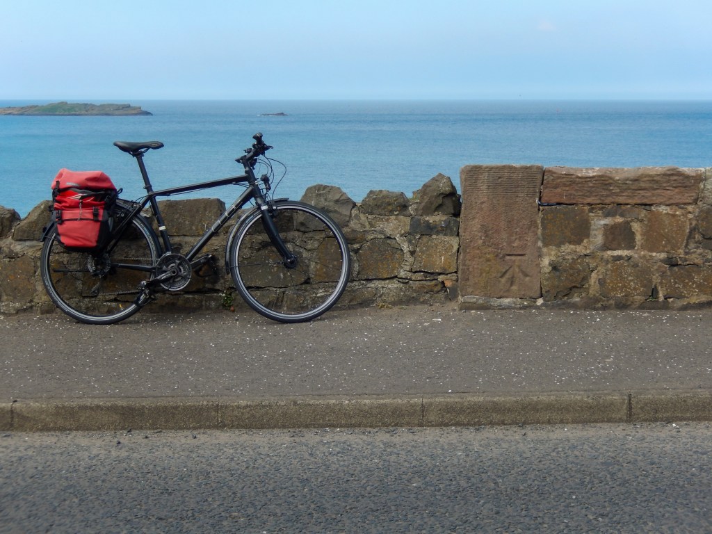
Originally part of a technical infrastructure, benchmarks have become heritage artefacts, hiding in plain sight to this day.
The Survey’s marks were inserted into a landscape already rich in memory and story. As their original purpose faded, the benchmarks passed from measurement into folklore. The sappers have long gone, but their marks remain: footsteps of the ghosts of Mountjoy across Ireland.
They are among the most enduring physical traces of the survey’s presence. They were intended to preserve a measured height for future generations and to anchor a national framework of levels. Height was measured above sea level. Yet one of the greatest surprises of the nineteenth-century Survey was the discovery that sea level was not level at all.
Footnotes
[i] Based on an article by Ian Sherry in the Dundalk Democrat.
[ii] Technically it is a measured height above Ordnance Datum, which is itself referenced to sea level.
[iii] Colby’s Instructions No. 60, See J.H. Andrews, A Paper Landscape, The Ordnance Survey in Nineteenth Century Ireland Appendix B. Oxford Clarendon Press, 1975.
[iv] “Stories from the people who put Ireland on the Map”, OSi, 2009, p80.
[v] Some of these stories are based on an article by Robin Riddihough about Gravity Surveys using Ordnance Survey Benchmarks in Ireland, reprinted in OS News Vol 2 No 3, December 1999.
[vi] See https://www.mayo.ie/getmedia/e44906c1-b287-40c0-885d-8980c39efa05/The-Crow-s-Foot-Trail-Information.pdf (accessed 29-05-2026)
See also: https://www.ouririshheritage.org/content/archive/topics/miscellaneous/benchmarks?
By subscribing, you will be notified of new posts.
