The Ordnance Survey, a military organisation operating under British authority, relied on the cooperation of local communities to make its maps.
The sappers spread out across Ireland in small detachments, far from barracks and immediate supervision. They climbed mountains, crossed bogs and worked in fields and farms, spending long periods among the local communities whose land they were surveying. They needed accommodation and provisions, employed local labourers and guides, and depended on local knowledge and assistance. Outside Dublin they normally lived in private lodgings, receiving allowances for accommodation and rations. They became a point of contact between a British military institution and the people whose land it was measuring.
Armed Soldiers or Unarmed Surveyors?
The first survey companies retained their military identity. Their officers belonged to the Royal Engineers and Royal Artillery, and their soldiers to the Royal Sappers and Miners. They were subject to military discipline, but their everyday duties were quite different from those of ordinary soldiers. They measured angles and distances, established surveying stations, erected signals, drew maps and carried out the calculations on which the Survey depended.
The most obvious visual clue to their military identity would have been their clothes and guns. But what they wore while working in the Irish countryside, and whether they routinely carried firearms, is not certain.
On parade, the men would ordinarily have worn the official uniform of the Royal Sappers and Miners. In the field they would have probably worn some form of working dress. Connolly’s History of the Royal Sappers and Miners includes an illustration entitled Uniform & Working Dress, 1825. This does not establish what the men wore while surveying in Ireland as sometimes they worked in civilian clothes, as they did when surveying the disputed North American boundary in 1839–40. I have found no evidence that they did so in Ireland.
One image frequently used to illustrate the Ordnance Survey in Ireland shows a group of soldiers in scarlet uniforms, three carrying firearms, standing in the foreground of a surveying encampment. Surveyors can be seen working with an instrument on a distant hillside, with tents and a tall observation signal completing the scene. It is a striking picture, but how accurately does it represent the men who surveyed Ireland?
The illustration is entitled Royal Sappers and Miners, 1837. Drawn by Charles J. Donovan, the original is held in the Royal Collection. It was reproduced in the Ordnance Survey’s Jubilee Book of 1887, alongside another of Donovan’s illustrations depicting the Royal Engineers of that year. I examined and photographed this page during a visit to Ordnance Survey headquarters in Southampton in 2024.
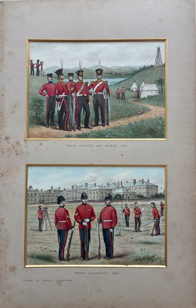
Royal Sappers and Miners, 1837; by Charles J. Donovan. Reproduced in the Ordnance Survey’s Jubilee Book (1887) and the upper one used later in “Ordnance Survey in Ireland An Illustrated Record”, produced by the Ordnance Survey in Belfast and Dublin. The original artwork is held in the Royal Collection, RCIN 916761. Photograph of the Jubilee Book taken by the author at Ordnance Survey headquarters, Southampton, 2024. The illustration does not specifically depict the Ordnance Survey in Ireland- the lower one appears to be Chatham in Kent.
See: Royal Collection catalogue record
There is nothing to establish that the picture depicts the Ordnance Survey in Ireland. It is a retrospective illustration of the Royal Sappers and Miners, one in the field, the other at their headquarters in Chatham, Kent and it was produced fifty years after the date it represents. Nevertheless, it has been reproduced in publications about the Irish Survey, where the prominence of armed soldiers can create a misleading impression of the nature of their work.
There is, however, a much earlier illustration showing the Ordnance Survey actually at work in Ireland. It is based on a contemporary pencil sketch of the measurement of the Lough Foyle Baseline in 1827–28, subsequently published by Captain William Yolland in 1847. It depicts men working beneath canvas shelters erected to protect Colby’s measuring apparatus. They wear practical working jackets rather than dress uniforms. At least one wears a flat, round cap resembling the military forage caps seen in later illustrations and photographs of Royal Engineers surveyors. A man stands with his back to the observer, wearing a hat and an overcoat overseeing the operation. No firearms are visible. Although the sketch does not establish precisely what uniform regulations applied, it provides a rare contemporary depiction of how the men appeared while carrying out their work.
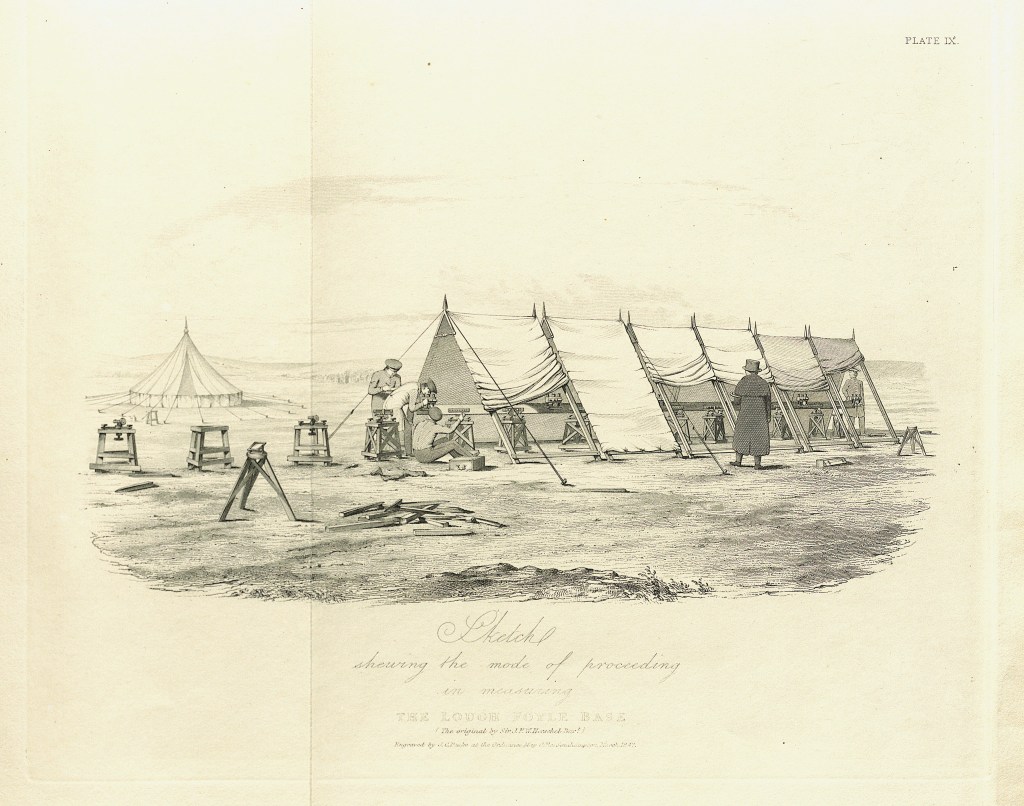
Measuring the Lough Foyle Baseline, 1827–28.
Sketch attributed to Sir John F. W. Herschel, engraved by J. C. Peake at the Ordnance Map Office, Southampton, March 1847. Published as Plate IX in William Yolland’s An Account of the Measurement of the Lough Foyle Base in Ireland (1847).
Other illustrations offer clues. Connolly’s history, published in 1857, includes a plate showing the working dress of 1854. A Royal Engineers officer in a dark blue coat stands beside sappers in red uniforms, with a surveying instrument between them. Behind them, men work around a surveying encampment. Although not a depiction of Ireland, it places the technical activities of the corps at the centre of the composition rather than its military identity, although they are clearly dressed in a working uniform.
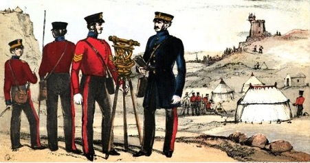
Working Dress, 1854.
Plate XVII from T. W. J. Connolly, History of the Royal Sappers and Miners, Vol. II (1857). A Royal Engineers officer in Blue and sappers in red are depicted with surveying equipment against the background of a field encampment. Although not specifically an Irish scene, the illustration emphasises the corps’ surveying duties and again not obviously armed.
See: Connolly’s History, Project Gutenberg
A later photograph, identified as a class of Royal Engineers Survey Instructors at Brompton Barracks, Chatham, in 1868, provides another contrast. It shows men wearing dark working frocks and forage caps, surrounded by surveying instruments, staffs and other technical equipment. No firearms are visible. The caps resemble those worn by some of the men in the much earlier Lough Foyle sketch.
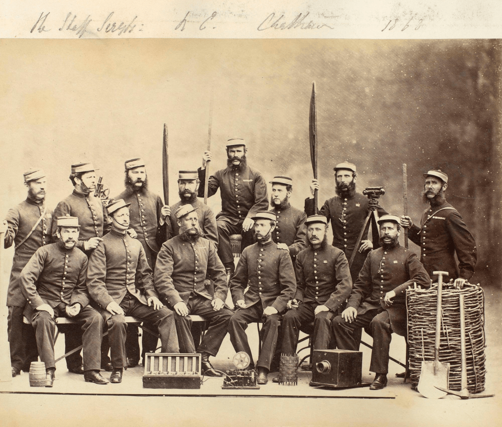
Staff Sergeants and Survey Instructors of the Royal Engineers at Brompton Barracks, Chatham, c. 1868.
No firearms are visible. The photograph is not identified as an Irish Ordnance Survey party, but illustrates the technical character of military engineering
None of these images establishes precisely how the first survey companies appeared when working in Ireland. Nor does the absence of firearms in an illustration or photograph prove that the men never carried them. But the distinction matters. The Survey was carried out by soldiers, working within a military organisation, yet engaged principally in a civil and scientific undertaking.
“The Survey is a Civil Service”
The distinction between the military status of the surveyors and the nature of their work was tested in 1834.
The High Sheriff of County Fermanagh called on the Survey’s officers and men to assemble as a military force for the preservation of the peace. Colby referred the matter to Dublin Castle and on 9 June, William Gosset replied on behalf of the Lord Lieutenant. His instruction was explicit: “the Survey is a Civil Service”. Its personnel could be called upon to assist the authorities as civilians, but their military organisation did not make them available for peacekeeping as a formed body. Sheriffs, magistrates and other authorities were to understand this distinction. Calling the surveyors away from their work, Gosset warned, would be “highly detrimental to the important Service” upon which they were employed. [i]
Colby insisted on military personnel carrying out the Survey and his motivation appears to have been entirely on standardising the work using military discipline, rather than carrying out a survey by force of arms. He resisted proposals to arm them, seeking police protection instead when necessary.
Dublin Castle’s immediate concern may have been to protect the progress of the Survey, but its instruction also had implications for the relationships on which that progress depended. Men who helped suppress a disturbance might find a different reception when they returned with their instruments. They remained soldiers, but their daily work required access, assistance and a measure of trust.
Among the Irish People
Connolly remembered the “kindness of the Irish” towards the sappers. In his history he also preserves something that official histories often miss: the names, experiences and, at times, voices of the ordinary soldiers who carried out the work. Many soldiers and civilians working on the Survey spoke and wrote of pride in their achievements, seeing the maps as bringing order and aiding prosperity. Some regarded them as essential tools for addressing Ireland’s longstanding grievances.
Connolly’s account, written in the 1850s, is unusually valuable, but it is not a detached, independent history. It was written from within the Royal Sappers and Miners, with a strong interest in recording and defending the achievements of ordinary soldiers. To Connolly, the sapper crossing an Irish field was primarily a skilled soldier doing difficult but worthwhile work. It is hard not to agree, but not everyone did.
The presence of British soldiers in Ireland had long been a sensitive and sometimes controversial matter, and the men of the Survey could not entirely escape the associations of the uniform they wore. Hospitality towards individual sappers did not necessarily imply acceptance of the administration that employed them. Some inhabitants feared that surveying would bring higher taxes or serve military purposes. Survey markers were removed, equipment damaged and, on occasion, personnel attacked. Local disputes over tithes, boundaries and land rights could shape the reception they received. The Survey belonged to the machinery of British rule, and encounters with its men were influenced by immediate grievances as well as wider political loyalties. [ii]
Some post-colonial historians have emphasised the Survey’s role as an instrument of British administration and its implications for Irish culture. The image of British soldiers in their redcoats moving through Ireland, measuring the landscape and recording its place-names, offers fertile ground for literary interpretation. Brian Friel’s Translations famously uses this encounter as an allegory of colonial power and cultural displacement. A playwright of course must be free to explore such themes through fiction, but the historian must distinguish dramatic interpretation from historical evidence. After all, as Friel said himself, “Drama is first a fiction, with the authority of fiction. You don’t go to Macbeth for history.” [iii] Historians including J. H. Andrews have challenged the portrayal of the Survey as solely an exercise in deliberate cultural suppression, arguing for a more nuanced understanding of its purpose and methods.
Inevitably, the reception the sappers received varied from place to place. He represented the Board of Ordnance and, ultimately, the British state, and so suspicion and local grievances made their work more difficult. Yet elsewhere communities offered accommodation, provisions and assistance. In daily life he was a working man, often wet, cold and exhausted, and dependent on those around him.
That dependence became particularly apparent during the Great Famine. Recalling his service in Donegal during the Famine, John Shearer remembered “very hard work in the mountains, not much pay and very spare diet” while in charge of a large survey party at Killybegs. He would have fared much worse but for the old warship Andromeda stationed in Killybegs Harbour as a provision depot supplying meal for the famine-stricken population. The surveyors’ circumstances were plainly not those of the starving population around them, but Shearer’s recollection shows how the conditions of the country affected the surveyors and their access to local supplies and provisions. [iv]
The maps were products of military organisation, scientific method and state authority, but their making was more personal. The soldiers lived and worked among the people whose land they were measuring. Their experience reveals something of the complicated relationship between British authority and Irish society, a relationship that cannot be explained entirely in terms of either goodwill or resistance.
Footnotes
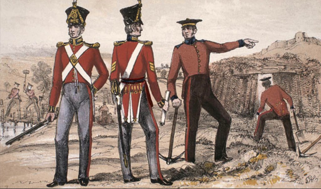
Header Image shows: Royal Sappers and Miners, uniform and working dress in 1825, ss illustrated in Connolly’s later history. The plate depicts the corps’ clothing, rather than an identified Irish surveying party. Illustration by George Bryant Campion. Source: T. W. J. Connolly, History of the Royal Sappers and Miners, Vol. I, Plate XIII.
[i] W. Gosset to Lieutenant-Colonel Colby, Dublin Castle, 9 June 1834, NAI, CSO/RP/1834/2567.
[ii] For an interesting discussion on how the Ordnance Survey was perceived across Irish Society see: Gillian Smith, “An Eye on the Survey”: Perceptions of the Ordnance Survey in Ireland 1824–1842’, History Ireland, vol. 9, no. 2 (Summer 2001), pp. 37–41. See: https://historyireland.com/an-eye-on-the-survey/
[iii] Friel, Brian, John Andrews, and Kevin Barry. “Translations and a Paper Landscape: Between Fiction and History.” The Crane Bag 7, no. 2 (1983): 118–24. http://www.jstor.org/stable/30060606. See p124. for the Macbeth quote.
[iv] John Shearer, “Recollections of service on the Ordnance Survey”, The Sapper, June 1901, reprinted in “Life on the Ordnance Survey,” Sheetlines: The Journal of the Charles Close Society, no. 120 (April 2021), pp. 47–48. Shearer’s memory was recorded more than fifty years after the event; nevertheless, the central elements of his story — the date, the location, the ship and its provisioning role — can be independently verified: the ship existed, it was at Killybegs, and its role as as a “store and provision depot, stationed at Killybegs” confirmed. See William Allingham’s diary, 21 July 1847 which records his visit to Andromeda in Killybegs Harbour: https://www.donegalculture.ie/media/jsqfhv3n/a-diary-compressed.pdf?utm and The Cork Examiner, 11 August 1847 which identifies Andromeda as the store and provision depot stationed at Killybegs: https://immigrantships.net/newsarticles/ireland1847_49.html?utm
By subscribing, you will be notified of new posts.
