Ireland’s townlands were defined and surveyed two hundred years ago, becoming part of the administrative and cultural geography that still shapes modern Ireland.
Colby’s soldiers, dragging their chains across the fields, were there to map the townlands. These ancient territorial divisions were to be fixed within a single system for a valuation that would be based on their area, quality, and productive capacity. [i] Yet across much of Ireland, their limits remained uncertain, disputed, or simply unknown. [ii]
Townlands had ancient origins and were rooted in early Gaelic systems of landholding. They had been shaped over centuries by kinship, agriculture, and topography, and their persistence owed less to formal definition than to custom and shared understanding. Their names, many of which were still in Irish, dated to the early medieval period and in rural Ireland, they remained deeply embedded in local identity and memory.
For administrators and surveyors, however, townlands presented significant difficulties. The hierarchy of Irish land divisions lacked the regularity expected by nineteenth-century administrators, influenced by Enlightenment ideas of order and measurement. They varied enormously in size, from a few acres to several thousand. In some places they did not exist at all, replaced instead by ploughlands, tates, or balliboes. Their names differed between local usage and official records, while their boundaries were frequently unmarked, disputed, or imperfectly known. Even their areas lacked consistency: land might be described in great acres, little acres, Irish acres, Cunningham acres, or English acres. [iii] If Parliament’s ambitions for valuation and taxation were to be realised, some form of standardisation was unavoidable.
Bringing order to these ancient territorial units would require more than geometry. As their boundaries touched directly upon property, identity, and local authority, neither Wellington nor Colby believed that soldiers should determine them. [v] So, in July 1825, under powers granted by Parliament, Richard Griffith was appointed Boundary Surveyor by the Irish Government at Dublin Castle. [vi] His task was to determine and mark the boundaries of townlands, parishes, baronies, and counties across Ireland, and to recruit local boundary surveyors to assist in settling disputed or uncertain limits.
Before Colby’s surveyors could begin to measure and map the townlands, Griffith’s boundary surveyors first had to define them. [vii] They moved systematically across the country, imposing structure on a landscape whose limits had often existed more in memory and tradition than in surveyed fact. Boundaries were examined, negotiated, and agreed upon through a combination of local testimony, documentary evidence, and established usage.
Where townlands already existed, they were delineated. Where they proved too large or impractical, they were subdivided. Where townlands were absent, alternatives had to be incorporated. Names, too, had to be settled. Local usage, older spellings, and administrative preferences rarely agreed. Griffith’s boundary surveyors became the local arbiters of this process, establishing the forms that would ultimately appear upon the map.
Only when the work of the Boundary Surveyors was complete could measurement begin. Boundaries, once settled, were marked on the ground and then physically traced by the officer-surveyors of the Board of Ordnance in a process known as perambulation. What had existed as a vague line was now becoming a measured one.
Chain lines could then be run between trigonometric points, their alignment maintained with ranging poles and their distances measured link by link. Boundaries were recorded where they intersected these lines or measured from them by offset. Each measured distance was checked against the wider triangulation network to ensure consistency and reveal errors. Boundaries were frequently fixed from more than one chain line, allowing discrepancies to be detected and corrected.
The meticulousness of this approach exposed weaknesses in the boundary work itself. Some of those appointed to define boundaries were less diligent than Colby demanded, and in certain cases, lines were incorrectly indicated or insufficiently examined on the ground. Complaints from Ordnance officers were frequent. Colby regarded such shortcomings as a direct threat to the survey’s integrity and insisted on strict adherence to procedure. Without rigorous control, he believed the work would risk becoming little better than the earlier Down Survey it was intended to surpass. [viii]
The resulting delay caused tension between the Boundary Department and Colby. The detailed survey depended entirely on the prior definition of boundaries, yet progress did not always match the pace expected by the surveying parties. Colby refused to sacrifice accuracy for speed. A survey that could not detect its own errors would fail, however quickly completed. A slower, more disciplined process was essential to produce a durable framework.
By the end of 1827, the Boundary Department under Griffith had become more efficient and increasingly aligned with the Survey’s progress. Slowly, the map began to emerge. First, the counties in the north, where the triangulation had been established earliest, anchored to the Lough Foyle baseline and linked across the channel to Scotland. County Antrim was surveyed in 1829, followed by Londonderry in 1830, Tyrone in 1832, and Donegal in 1833. From this northern foundation, the survey extended steadily southwards. These earlier northern sheets omitted many field boundaries, a policy later revised, and from the early 1840s, the maps were progressively completed with additional detail.
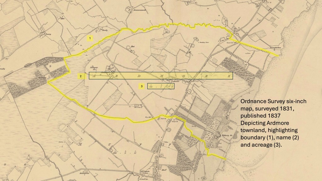
Map reproduced with the permission of the National Library of Scotland, CC-BY (NLS) https://maps.nls.uk/
As the survey advanced, a fundamental transformation began to take place. Townlands that had once been fluid in their definition became fixed. Their boundaries were measured and recorded, their areas calculated, their names standardised and their outlines engraved on the map. What had previously depended on local knowledge and custom was formalised into a permanent record. In some cases, the process simplified or altered ancient forms. Once fixed on the map, these boundaries and names acquired lasting official authority.
The framework established during the survey proved remarkably durable, shaping administrative practice for generations. Even today, townlands remain part of the official and cultural geography of Ireland. Although modern boundaries are maintained through highly precise digital systems, the foundation established by Griffith and mapped under Colby remains visible beneath them, embedded within the administrative geography of the state. [ix]
Every townland also carried a name. If boundaries could be uncertain and contested, the names attached to them were no less so. The same was true of other placenames, carried in Irish speech, local memory, and older manuscripts. The challenge facing the Survey was how those names would be recorded, interpreted, and ultimately set in English upon the map.
This is the subject of the next two posts.
Footnotes
[i] The Spring Rice report, H.C. 1824 (445) viii, 79. As quoted in Appendix A, “A Paper Landscape”, J.H. Andrews, 1975
[ii] An Act of Parliament 5 Geo. IV, c.112 (1825), was “An Act for consolidating and amending the Laws relating to the Grand Jury Presentments in Ireland.” It linked: county taxation, valuation, and territorial divisions, creating the administrative pressure for a more uniform valuation framework by reforming how county cess and local presentments operated. It drove the need for accurate boundaries, standardised townlands, and ultimately the Ordnance Survey in Ireland .
[iii] “Of Gneeves, Townlands, Civil Parishes & Station Districts”, Fossa Historical Society, Chapter 23.
[iv] A brief biography of Thomas Larcom will appear in a later Blog
[v] The Origins of the Ordnance Survey in Ireland , Finnian O’Cionnath, 2024.
[vi] Richard Griffith (1784–1878) was one of the central figures in the scientific and administrative transformation of nineteenth-century Ireland. Trained as a civil engineer and geologist, he became widely respected for his systematic geological survey of the country and for his work on infrastructure, particularly roads and public works. He was appointed Boundary Surveyor by the Irish Government in 1825, in preparation for the Ordnance Survey and the valuation system later established under the Valuation Act of 1826 (7 Geo. IV, c. 62). His appointment as Commissioner of Valuation in 1826 ensured continuity between the definition of boundaries and their use in taxation. His most enduring legacy lies in what became known as Griffith’s Valuation. This work, alongside the Ordnance Survey six-inch map, provided, for the first time, a consistent, mapped record of occupiers, holdings, and values across Ireland, and it remains an indispensable source for historians and genealogists. A fuller scholarly account of his life and work can be found in the Dictionary of Irish Biography: https://www.dib.ie/biography/griffith-richard-a3593
[vii] It is important to note that Parliament did not legislate for the triangulation or for a six-inch map. Instead, it created the administrative problem that such a map would solve: how to define, measure, and value the land of Ireland with sufficient consistency for taxation and government. Colby’s soldiers, in a unit that would become The Ordnance Survey, became the instrument through which that ambition was realised, and that work arose separately through the recommendations of the Spring-Rice Committee (1824), Treasury and Board of Ordnance decisions, and executive authority exercised through Wellington, Colby, and Dublin Castle.
[viii] The Down survey was carried out by William Petty following the Cromwellian wars for the purposes of confiscating land. “Lt Colby’s report to Sir Henry Hardinge KCB on the present state and progress of the Irish Survey”, February 15th, 1827. NAI, OS/1/2.
[ix] They continue to underpin parishes, baronies, electoral districts, and many systems of local reference. In the Republic of Ireland, the office of Boundary Surveyor survives in limited form, while in Northern Ireland boundaries largely remain fixed unless altered through legislation.
By subscribing, you will be notified of new posts.
