From Framework to Field –
“the Red Coats were just across the foot of Cnoc na Mona, dragging them aul chains and peeping through that big machine they lug about everywhere with them …” [1]
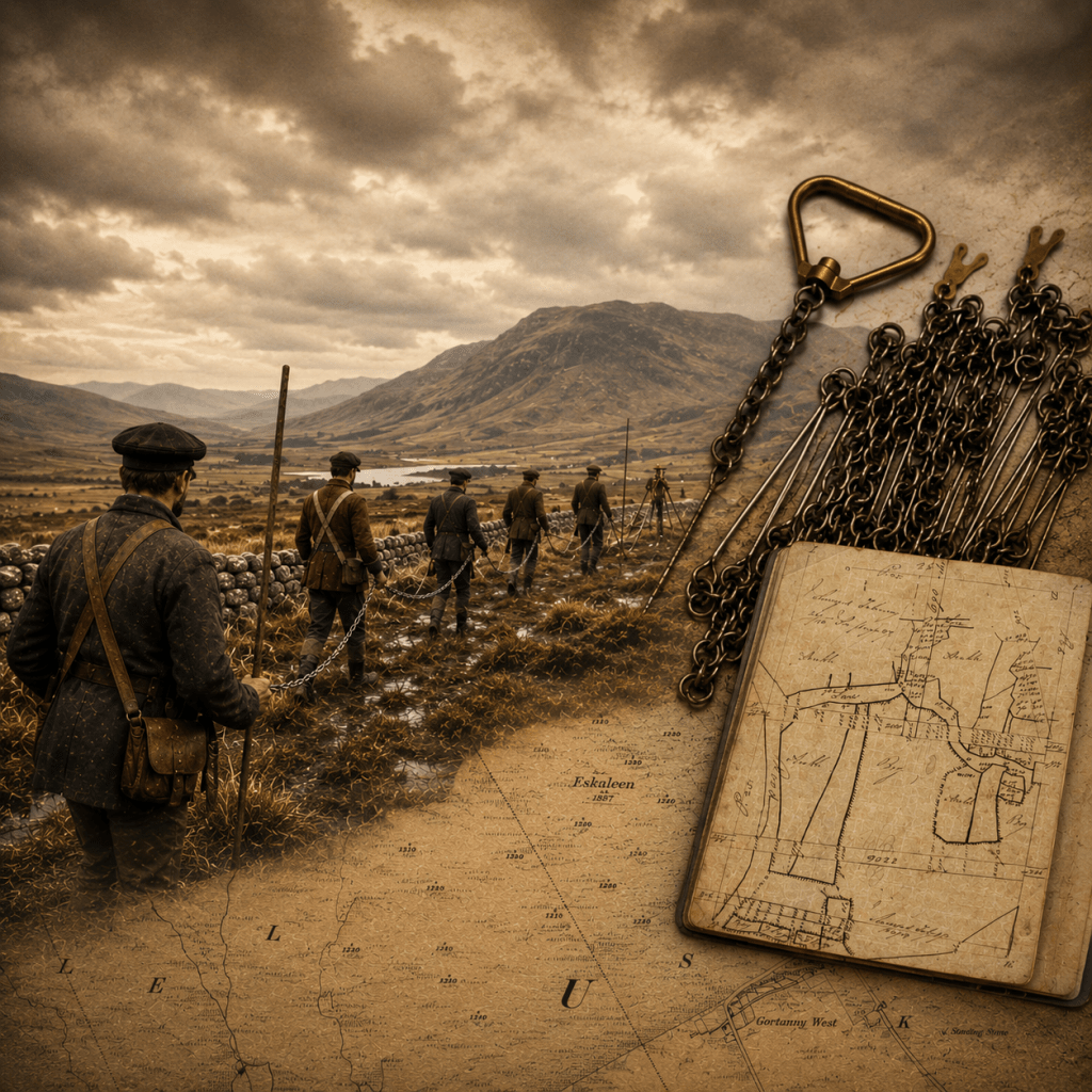
To those who watched them, the surveyors were a visible intrusion into the landscape. Soldiers carrying chains, poles and instruments moved steadily across green fields and ancient boundaries, measuring what had long been known through memory and custom. They brought with them a new way of seeing the land: translating it into measured lines, fixed points and anglicised names.
The triangulation that fixed the mountains and coastlines provided a precise framework, but it remained incomplete. It now had to be carried across bog, boundary and bawn, and reduced to measured lines that could be walked, checked, and recorded. This was not abstract work, but of men on the ground, the soldier surveyors and civilian labourers. It is here, in the laying out of the chain, that the detailed survey truly begins.
More than a century later, surveyors still remembered the ending of that world:
“That Thursday, a gloriously warm day, 6 November 1969… put paid to extensive chain surveying in Northern Ireland for all time.” [2]
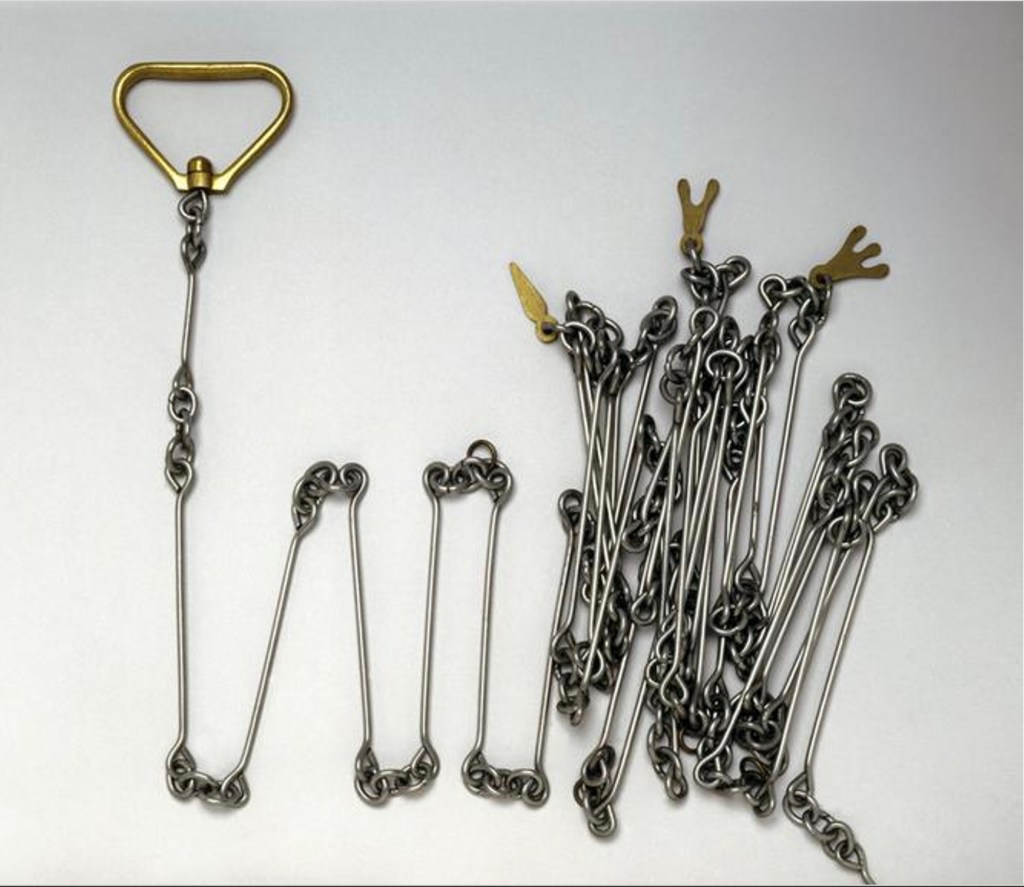
Gunter’s chain—66 feet long and divided into 100 links—was folded, secured, and consigned to the store. Its disappearance passed with little ceremony, remembered mainly by those who had used it, an instrument whose lineage stretched back centuries.
Devised in the early seventeenth century by the English mathematician Edmund Gunter, the chain provided a practical and standardised means of measuring distance. Ten chains measured a furlong, eighty chains a statute mile, and ten square chains an acre. It remained in use well into the twentieth century, its endurance reflected not simply professional conservatism, but trust. In surveying, new methods are only adopted when they demonstrably improve accuracy and utility.
The purpose of the survey demanded such certainty. The six-inch mapping of Ireland had an important cadastral function.[3] Boundaries had to be fixed, features recorded, and areas determined in a way that could support the valuation of townlands and the administration of the country. The triangulation network provided control, but it was the chain that translated that control into measured reality.
The work was divided into roles, with surveyor-officers directing the operation, controlling alignment and recording observations. Alongside them worked soldier-sappers and civilian labourers—the “draggers of the chain.” They carried the equipment, dragged the chains, held the ranging poles, cleared lines of sight, and laid and relaid the chains across the land.
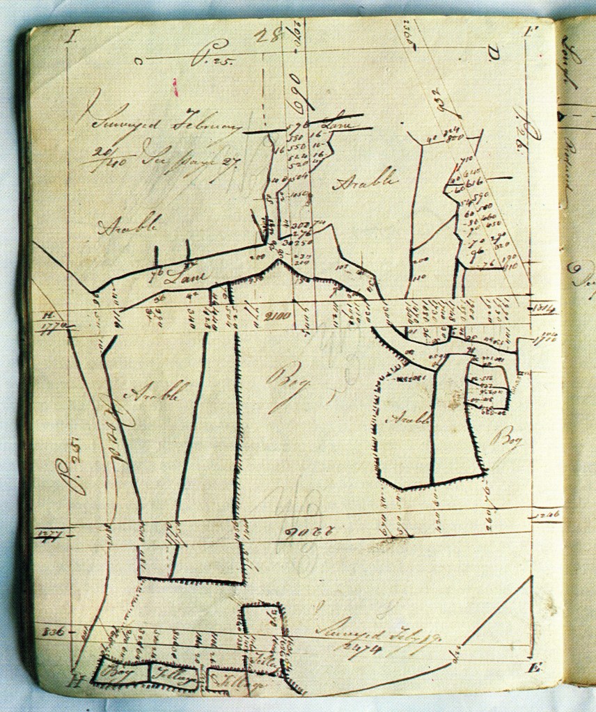
Chaining was a direct method of measurement. A line was established between two known points, aligned by a surveyor using ranging poles held by assistants. The chain was then laid out along that line, its full length extended, counted, lifted, and laid again. Distances were recorded in chains and links. Features intersecting the chain line, or lying at a distance from it, were measured by offsets and entered into a field book, accompanied by a sketch. Each chainline demanded fastidious attention.
Source: Ordnance Survey in Ireland, An Illustrated Record.
The work was repetitive and exacting. Each measurement depended on alignment, tension, and careful counting. Errors could arise from a sag in the chain, uneven ground, or simple miscounting. Chains were regularly calibrated against known standards, and measurements were checked and repeated where necessary.
Sloping ground introduced further difficulty. Early surveyors measured directly along the ground and corrected the result mathematically to obtain horizontal distance. Later, they adopted the practice of “stepping” the chain down slopes in short level sections, measuring the horizontal distance directly.
Accuracy was tested, not assumed. Measured distances between triangulation points were compared with those calculated from the trigonometrical network, while important detail was often fixed from more than one chain line to provide independent checks.
Although faster methods existed, Colby distrusted expedients that sacrificed control for speed. Traversing, which relied on successive angles and distances from point to point, was useful in obstructed terrain but allowed errors to accumulate unnoticed. Wherever possible, Colby insisted on direct measurement, and where traversing could not be avoided, he required it to be checked by cross-cutting chain lines. His system prioritised accuracy over expediency.
The terrain offered little concession. Fields were bounded by hedges and ditches. Lines were obstructed by stone walls and rivers, bog yielded underfoot and slopes required constant adjustment. In poor weather, the ground grew wet, boggy and glaggy. The chain became heavy and difficult to manage. Each measurement required coordination: one man aligning, another holding, others extending and marking.
Colby’s system extended beyond the field. Measurements and sketches recorded in field books were sent to the drawing office and converted into fair drawings, which were then returned for verification before engraving. The process created a check between observation and representation, allowing errors to be identified before publication. It was exacting in design and exhausting in execution.
Yet it was through this labour that the survey took form. The abstract geometry of triangulation became measured lines across the landscape. Skilled observation remained under the control of surveyor-officers, while sappers and civilian labourers carried out the physical work of chaining, ranging, and clearing lines of sight. Each measured length and field-book note contributed to a larger whole, combining systematic method, local terrain, and human effort in the production of the map.
The survey was under pressure to progress. The Valuation required accurate maps, and Parliament expected results. Yet Colby resisted expedients that would compromise reliability. His rejection of widespread traversing, his insistence on calibration and checking, and his requirement for boundary verification all imposed delay. It was not only external criticism he had to confront; some of his own officers became impatient with the system. The balance he sought was not between speed and accuracy in the abstract, but between control and uncertainty. In Colby’s view, a survey that could not detect its own errors would ultimately undermine the authority on which the map depended.
The authority of the map depended on the discipline with which it was applied, as well as on its geometry. What began as an abstract framework of triangles and calculated distances found its expression on the ground, in the repeated laying of the chain. Each measured length and recorded line formed part of a system designed to resist error and enforce trust.
To those who first watched it unfold, it may have seemed intrusive: men dragging chains under military direction across fields long known through memory and custom. Yet it was through this methodical, systematic, and often exhausting labour that the landscape was fixed and recorded. The land was not simply observed, but secured in practice, chain by chain.
Footnotes
The account draws on various sources about chainline surveys, and on the author’s practical experience of chain surveying using steel tapes.
Header Image AI generated
“Ordnance Survey in Ireland: An Illustrated Record“, Published by The Ordnance Survey of Ireland and the Ordnance Survey of Northern Ireland, 1991.
Other sources and notes:
[1] “Translations”, by Brian Friel, Faber and Faber, 1981.
[2] “The Limelighters and Me. An Ordnance Survey Assistant Grade III” the unpublished memoir by the Ordnance Survey of Northern Ireland surveyor, Ian Sherry.
[3] The six-inch survey itself was not formally a cadastral survey in the strict continental legal sense, however it became foundational to Griffith’s Valuation, and boundaries and areas were critical. It effectively functioned in a cadastral-administrative role.
By subscribing, you will be notified of new posts.
