The Ghosts of Mountjoy stretch further back than the Ordnance Survey. This story begins with the Rod of Kha and the ancient authority of measurement.
The surveying of Ireland was more than an act of measurement. It imposed authority, interpretation, and control, and was carried across mountains, bogs, boundaries, and language itself.
This is the first in a series of posts forming a chapter that traces the work from its deepest origins, from an ancient authority for measurement, through the physical labour of the chain surveyors, to the fixing of boundaries and names upon the map. Along the way, we encounter the Ghosts of Mountjoy: soldiers, scholars, administrators, and remnants of an older Gaelic world that lingered within the landscape that the Survey sought to define.
*****
The authority with which a map is produced begins before it is published. It begins with measurement: with the tools, the judgment, and the trust placed in those who attempt to bring order to the chaos of land. It requires the trained eye of the surveyor, a modern term derived from the Anglo-Norman surveiour—one who oversees.
Long before governments carried out triangulation to fix their nations, the authority of a surveyor relied on simpler methods and instruments, such as rods, ropes, and levels. One such instrument, preserved for four thousand years in the tomb of an Egyptian architect/surveyor, offers a rare ancient glimpse into the power and authority of those who measured.
*****
The tombs embedded in the cliffs of Deir el-Medina had long since been desecrated, but the debris below suggested something more than the usual disturbance. To the experienced eye of the Italian archaeologist Ernesto Schiaparelli, the rubble warranted closer attention. For weeks, his team sifted rock and sand, clearing shafts, tunnels and empty chambers. Then, on 16 February 1906, they uncovered an irregular opening, with a set of steps descending steeply into darkness.
They entered cautiously, as if crossing into Duat itself—the shadowed and uncertain realm through which the dead were believed to travel. Two stone walls were broken through before they came to a sealed doorway, the entrance to a burial chamber. It appeared almost modern in its finish, and Schiaparelli, testing it, jokingly called for a key. None came. He banged on the door, and an echo travelled inward, into a space beyond that had remained undisturbed for millennia. An eyewitness remembered how “ … one felt the mummy, in the darkness beyond, might well think that his resurrection call had come.” [i]
Inside were two chambers where the mummies and possessions of Kha and his wife, Meryt, lay. Their tomb had not been plundered. Furniture, clothing, and personal effects remained in place, preserved as a complete record of a life. Among their effects were the tools of Kha’s profession: a simple stool, from which he might have supervised work; a level for judging the horizontal and vertical; and a writing tablet, likely used for recording measurements and calculations. There were also two rods.
The first rod was wooden, one cubit in length and hinged at its centre. It showed clear signs of use. It had been carried, handled, and relied upon, found in its leather case, placed deliberately among his possessions. This was not a symbolic implement, but a working instrument, valued enough to accompany him into the afterlife.
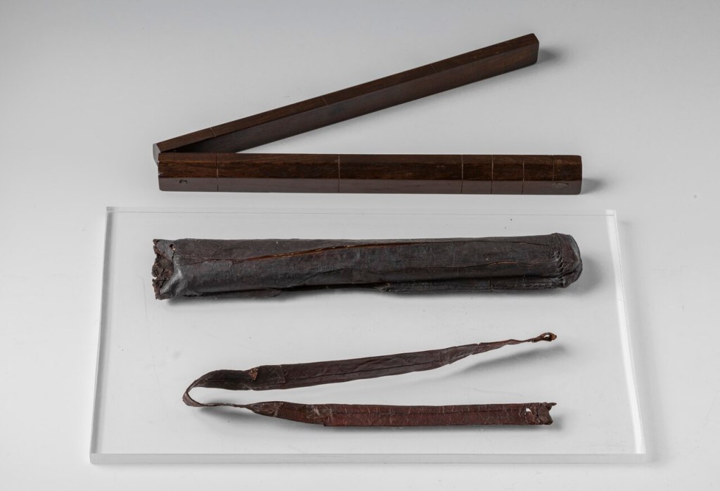
The working Rod of Kha.
S.8391 (Museo Egizio, Turin Italy).
Reproduced under the Creative Commons CC0 1.0 Universal Public Domain Dedication.
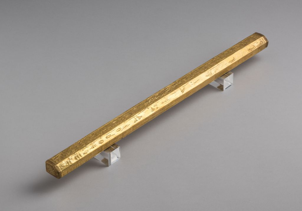
The second rod was different, covered in gold leaf and inscribed with the name of Amenhotep II. It appeared to be ceremonial and almost certainly a gift. Where the first represented practice, the second signified authority, depicting the relationship between measurement and power, between the act of surveying and the state that required it. [ii]
Kha held the title imy-r kat m Set-Maat, meaning ‘overseer of works in the Place of Truth’. It was a title that denoted responsibility for ensuring that construction and layout were carried out correctly, that measurement was applied consistently, and that the results could be trusted. It was not an honorary title. It was, in essence, a technical office under the direct authority of the Pharaoh. The same logic is recognisable today in the authority that states give to their national mapping agencies: the land must be measured in a way that others can rely upon.
The Egyptians applied this logic systematically to their administration of the State. Surveying was not confined to monumental construction. With rods, levels, and taut ropes, they set out lines and angles, using geometric relationships that approximated what would later be formalised by Pythagoras, one thousand years later. These “rope-stretchers,” or Harpedonaptae, [iii] re-established field boundaries after the annual flooding of the Nile, ensuring continuity in landholding. Their work required calibration against standard units, most commonly the cubit, derived from the human forearm but fixed in practice through physical reference rods.
Those who controlled such standards held authority. [iv] Measurement, even in its earliest forms, was not neutral; it defined ownership, obligation, and value.
The origins of this practice extend further back, probably to the transition to settled agriculture in the Neolithic period. Established cultivation probably created the need to define and manage plots of land. Babylonian clay tablets, dating from over three millennia ago, depict fields using geometric forms that predate Greek theory. [v] Measurement was already being used to organise space, record boundaries, and resolve disputes.
The Greeks would later provide a theoretical framework for understanding geometry and the shape of the Earth. The Romans applied these principles with characteristic discipline. Their surveyors—Finitores and later Agrimensores—laid out towns, roads, and agricultural land with a level of standardisation that reflected the administrative needs of an empire. Their methods were recorded in the Corpus Agrimensorum Romanorum, an early attempt to codify surveying practice, just as Colby did with his “Blue Book.”
Across these civilisations, a consistent pattern emerges. Measurement begins as a local, practical activity, constrained by instruments and terrain. It is applied carefully over limited areas, each survey largely independent. Yet as instruments improve and understanding deepens, its scope expands. The curvature of the Earth, once an abstract concept, becomes a practical consideration. Distances measured on the ground must be reconciled with a larger spherical surface. Surveying evolves from the local to the regional, and eventually to the national and then global.
The critical development in this evolution was triangulation. By measuring angles within a network of triangles, surveyors could extend control over large areas without the need for continuous direct measurement. Distances could be derived from a limited number of carefully measured baselines, and individual surveys could be linked into a coherent whole. For the first time, it became possible to construct maps at national scale not from reports or approximations, but from measured reality.
This shift did not remove the need for instruments such as Kha’s rod; rather, it redefined their role. Survey organisations continued to maintain standard units of length—embodied in physical rods and bars—well into the twentieth century. Standards for the yard, the toise, the metre would, in time, be superseded by measurement defined in terms of electromagnetic wavelengths. The principle is the same.
Measurement became both more abstract and more demanding. The framework could be established through geometry, but it still required confirmation on the ground. Precision depended on the consistent application of method, on the reliability of instruments, and on the discipline of those who used them.
From the rod of Kha to the triangulations of the modern state, surveying evolved into a system capable of fixing entire landscapes with precision. Yet even at its most refined, measurement remained abstract until it was carried onto the ground. Geometry could define a framework, but it could not, by itself, produce a map. That required translation into lines that could be walked, distances that could be measured, and detail that could be recorded. It is at that point, where theory meets the practice and the land itself, that the survey truly begins.
The next post will deal with the chain surveys carried out in Ireland for the six inch maps.
Footnotes:
[i] Arthur Weigall, Inspector of Antiquities for Upper Egypt, witnessed the opening. From: “The Intact Tomb of the Architect Kha in the Necropolis of Thebes” by Ernesto Schiaparelli, Adarte, 1920, English translation, Adarte-Turin, 2008
[ii] “The folding cubit rod of Kha in Museo Egizio fi Torino, S.8391” in Proceedings of the XI International Congress of Egyptologists, Florence, Italy 23-30 August 2015
[iii] The practitioners later described by Greek writers as the Harpedonaptae were active in Egypt at least two millennia before Pythagoras, applying geometric principles in practice long before they were expressed in theory.
[iv] “Beyond Measure: The Hidden History of Measurement” James Vincent, Faber 2022
[v] A Babylonian tablet, Si.427, held in Istanbul Archaeological Museum, dating from around 1800 BC, shows surveyors using geometric rules to define land boundaries, over a thousand years before Pythagoras would give those relationships formal expression.
By subscribing, you will be notified of new posts.
