The triangulation of Ireland was both a scientific and a human achievement, forged through physical endeavour in hazardous landscapes.
Private Alexander Smith set out from Buncrana with a heavy load for the summit of Slieve Snaght: a side of mutton, a jar of spirits, provisions, and a bag of letters. It was late, and the weather was already turning, but he had walked this route regularly and did so again without complaint, moving steadily, as if the mountain imposed no more burden on him than level ground. By the time he reached the upper slopes, snow was falling, and the track had disappeared. He pressed on into the storm, alone, climbing towards a camp he could no longer see.
The wind strengthened, and the snow swept across the ground. He pressed on, wrapped in his greatcoat, his cap pulled down against the cold, climbing into the storm. The track, never clear, disappeared altogether as the snow and darkness closed around him and the wind drove against his face, forcing him off his route. At some point, he lost all sense of direction.
He wandered through the night, carrying his load, searching for ground he might recognise. The cold set in, first in his hands and feet, then through his body. The effort of movement kept him from stopping, but it did not bring him any closer to the camp. Exposed on the mountainside, alone in a landscape without mark or feature, it must have been lonely and frightening.
By morning, the weather had eased and so at first light, he found his bearings and climbed on, steadily once more.
At the summit, Drummond and the Sappers witnessed a solitary figure emerging from the snow, spent, his clothes stiff with frost, his face marked by exposure. Impressed at his endurance, they were amazed to discover he still carried everything with him, the letters bringing news from home and instructions from Colby. [i]
*****
Smith’s experience in the mountains was by no means exceptional. Reaching the summits was described as the “really laborious part of the business”. [ii] Colby himself once spent five days and nights of coach travel from London to the highlands of Scotland, immediately joining his men in the mountains. He then led a “Station Hunt” and, over one day, covered thirty-nine miles across mountains and glens, off the beaten track. Over a period of twenty-two days, he walked nearly six hundred miles.[iii] Colby led from the front.
Horses and mules could sometimes help carry equipment, but in Donegal the peat bogs were too soft, uneven, and exhausting underfoot. Sensitive, fragile instruments had to be carried carefully on men’s shoulders to the bleak and exposed mountain tops, along with tents, water, provisions and fuel.
At the station, they built a camp. Stone was gathered and set into low walls, and a tarpaulin roof fixed in place, any gaps packed with moss and turf against the wind. Inside, there was space to cook, to dry clothes and to sleep. It was a small defence against the weather.
The instrument had to be protected, too. A shelter was built around Ramsden’s three-foot theodolite, a 200lb precision instrument that could measure an angle to a fraction of a degree. [iv] Once it was set, they watched and waited for the weather to clear. It could take weeks if the cloud settled over the summits and did not lift.
“I am told that the weather is free below … Here we have interminable fog. The night is likely to be wild but we are secured by huge stone traverses that we have nothing to fear…” [v]
They watched and waited. In a moment, the clouds would lift or sink into the valleys, leaving the mountain tops clear above an ocean of mist, the atmosphere calm and steady. A distant signal might show on a distant peak as a flash of reflected sunlight by day, or a pinprick of burning limelight by night. The first man to spot it earned a shilling, or a guinea for the longest lines. [vi] The angular observations could then be completed.
*****
The risks were constant, even as they observed the angles. In 1828 Lieutenant Portlock, then the senior observer at many stations, recorded a lightning strike on Cuilcagh:
“It was a stormy, unsettled day …. I was fixed to the Observatory. A violent hailstorm came on, … when I received a smart Slap … on the top of my head from a passing flash of Lightning … I just saw Gunner Phibbs … roll round and tumble to the ground. He rose again, but instantly fell and remained in a kind of torpor, breathing heavily, for about twenty minutes, when he began to recover. As soon as he could walk, I sent him down the Hill, when he was bled.”
Phibbs survived and the work continued. Portlock’s account is matter-of-fact. Exposure, exhaustion, disorientation, and at times sudden danger, were accepted conditions of the work. The hazards varied, but the exposure was relentless.
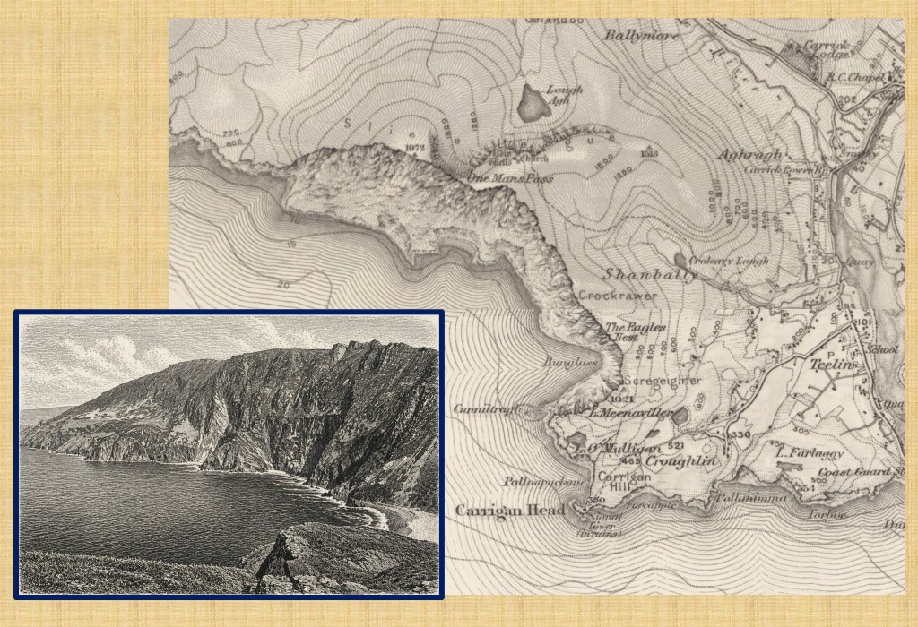
On some peaks, the danger lay in the landscape itself. Nowhere more so than at Slieve League in the south-west of Donegal, where cliffs rise above the Atlantic Ocean. The surveyors described it as the wildest headland in Britain and Ireland.
The approach to the station tested not only endurance, but nerve. To reach the highest point they carried the theodolite across the “one-man’s pass”, a narrow ridge no wider than a boot, with steep drops two thousand feet to the Atlantic on the left, and one thousand feet to Loch Each to the right. Here Portlock and his survey party spent Christmas of 1827, working through the winter months, determined to make enough progress to begin the detailed mapping.
The place has not changed: to stand on this spot and peer over the edge at the wild Atlantic Ocean crashing at the foot of cliffs below it is still a test of nerve as much as footing, best avoided in wind, rain or poor visibility.
*****
It is easy to treat the triangulation as an abstract network of lines, a mathematical framework of triangles, a step in the development of geodesy. It was an intellectual achievement as well as the technical foundation for mapping. All are true, but incomplete.
The other part is the physical effort that made it possible. Men carried instruments up mountains, camps were built from stone and turf, and weeks spent waiting for the weather to break. The work demanded endurance as well as precision. Long periods of exposure were followed by brief moments of clarity, in which everything depended on a steady hand and a clear line of sight. The whole enterprise relied not only on instruments and calculation, but on men like Smith, whose physical and mental stamina carried the work to the summits and sustained it there. Through such effort, the triangulation was secured.
Wordsworth’s “geographic labourer” captures a sense of this. [vii] The surveyor had to be physically strong and mentally strong too, a labourer and a philosopher. Science, calculation and judgement were inseparable from strength, persistence and hardship. These qualities were tested on the summits of Ireland. The light seen across the mountains, the angles carefully measured, the lines drawn across the landscape, all depended on this effort.
From these lines the maps were drawn. This will be the subject of the next chapter and blog posts. The maps themselves would endure long after the camps had been dismantled and the surveyors departed, the legacy not only of science, geodesy and cartography, but of the men involved and their physical endeavour in the face of nature’s processes.
Footnotes:
The map used in the header image of Slieve League is a compilation of two maps reproduced with the permission of the National Library of Scotland, CC-BY (NLS) https://maps.nls.uk/
The drawing of the Slieve Leage cliffs is based on a photo by the author.
[i] Drummond noted Smith’s endurance and reliability and promoted him to second corporal. He remained in service, rising to the rank of sergeant before his discharge in 1839. By then, the years on the mountains had taken their toll. He left with a chest complaint he attributed to exposure on Slieve Snaght. From The Project Gutenberg EBook of History of the Royal Sappers and Miners, Volume 1 (of 2), by T. W. J. Connolly para 268.
[ii] Major Dawson, writing to Lt. Col. Portlock, quoted in Portlock’s Memoir of the Life of Major-General Colby”, 1869.
[iii] “Memoire of the Life of Major General Colby, together with a Sketch of the Origin and Progress of the Ordnance Survey of Great Britain and Ireland” Lieutenant Colonel J. E. Portlock, Seeley, Jackson & Halliday 1869.
[iv] 1/3,600th of a degree
[v] Letter Portlock to Colby, 4th October 1827, quoted in Close p 130.
[vi] “Account of the Principal Triangulation”, Clarke, Eyre and Spottiswoode, 1858, p52.
[vii] See blog post “18. On Exalted Hills”
By subscribing, you will be notified of new posts.

Response
[…] → Read Post 22 […]
LikeLike