The endurance, innovation, and romance involved in measuring Ireland from remote mountain tops during the triangulation.
Written with a Slate-pencil, on a Stone ...
by William Wordsworth [i]

“… Know, if thou grudge not to prolong thy rest
That on the summit whither thou art bound
A geographic Labourer pitched his tent
With books supplied and instruments of art
To measure height and distance; lonely task
Week after week pursued! – To him was given
Full many a glimpse (but sparingly bestowed
On timid man) of Nature’s processes
Upon the exalted hills. …..”
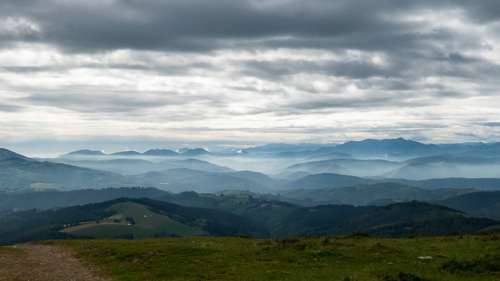
The mountain summits of Ireland can be wild places. The wind blows without obstruction, and the cloud settles without warning, confusing the ill-prepared and the well-prepared alike. Two hundred years ago, a small group of men worked on these peaks in rain and snow, the unsung heroes of one of the most ambitious scientific enterprises of the nineteenth century. Their task, to measure the country, was deceptively simple but required cutting-edge science, engineering, and mathematical precision, and, above all, endurance, ingenuity, and a willingness to live for weeks at a time on the tops of mountains.
The foundation of that work began on the flat ground by Lough Foyle [read here]. Yet, even before the baseline had been completed, the angular observations rose into the hills surrounding Lough Foyle, and across the sea to the Scottish mountains. From there, distance and position could be computed through long chains of triangles, stretching from peak to peak, crossing water and land without distinction, geometrically linking Ireland to Britain and a wider, measured world. [ii]
The ambition and reach of the enterprise become apparent from one of these summits, Slieve Donard, in the Mourne Mountains. From there, observers looked out across the Irish Sea to the hills of Scotland and Wales. Merrick and Criffel lie more than 70 miles to the east, Snowdon further south, more than 110 miles away. Each distant point would be brought into focus through careful alignment and patient observation of angles. Separated by the Irish Sea, they were to draw the islands into a single, measured, united whole.
The scale and the detail of the task were remarkable. Thirty-four principal stations were established, forming the apexes of triangles that covered the island. The distances between them were not modest; many lines exceeded thirty miles, some extended beyond one hundred. These were not local measurements, but observations made across entire regions, carried out with a discipline inherited from military practice and a rigour drawn from the most advanced science of the period. [iii]
A small story captures both the spirit and the fragility of the work. In 1826, from the top of Slieve Donard, the surveyors sought to observe Scafell in the Lake District, some 111 miles away. The surveyors had spent weeks waiting for the weather to clear. As the sun rose behind the Cumbrian mountains, the outline of Scafell emerged faintly on the horizon, its profile just distinct enough to offer a target. Colonel Thomas Colby, the driving force behind the survey, attempted to bisect it with Ramsden’s Great Theodolite, the 200 lb precision instrument at the heart of the operation. At that moment, an officer accidentally struck the instrument with his elbow. The observation was lost, the opportunity passed, and despite all subsequent efforts, the measurement was never completed, a single disturbance undoing days and weeks of preparation.
Even before the observations could begin, the mountain tops had to be prepared. Not long after Colby received his orders from Wellington to begin work in Ireland, survey parties moved from summit to summit. A drilled hole in a stone marked the precise points of measurement. Signals were erected over them so they could be identified from afar. These were not casual markers, but carefully positioned beacons designed to be “bisected” through the telescope of a theodolite. The observer aligned the crosshairs on the distant target, and the angle was read and recorded. Precision came from repetition, and accuracy through interconnection. Each station was observed repeatedly as a node in a wider network, not fixed by a single measurement but by its relationships to many others. The same point seen from multiple directions, under different conditions, could then be established with confidence.
On paper, the network was a triumph of rational design. On the ground, it depended on men climbing mountains, hauling equipment, erecting signals, and waiting, often for weeks, for a clear line of sight. Even if the geometry worked, the weather often did not, and when the weather cleared, it could be over in minutes. Observers had to be quick, consistent and precise. A distant target might appear as a faint glint or barely perceptible form. The theodolite had to be brought to bear quickly, cold, numb fingers had to turn small thumb screws, the crosshairs aligned, the angle measured, and another piece of the framework secured. From such fleeting moments, repeated time and again across the hills and mountains of Ireland, the map would eventually emerge.
*****
There is something inherently striking and romantic in this process, although climbing a peak because it was there was not for them. Their purpose stretched beyond the personal challenge. The surveyors were engaged in meaningful, disciplined, methodical work, and they operated at the limits of what was physically and technically possible. It was both intellectual and actual, abstract and intensely practical. It unfolded not in offices, observatories or lecture halls, but on exposed summits, where cloud and wind were constant companions. For people living nearby, below in the valleys, these activities were highly visible but essentially enigmatic. Temporary camps, men with large brass theodolites, beacons and flagpoles, signal towers, and bright lights appearing on remote peaks. Their purpose was far from obvious.
Wordsworth’s “geographic labourer” captures the essence of this work: a solitary figure on a distant summit, instruments aligned, waiting for clarity. His image, poetic and allegorical, was close to reality. He suggests that measurement is not merely technical, but a way of seeing and revealing patterns in nature that remain hidden to those below. In this sense, the surveyor mirrors the philosopher, stepping beyond the ordinary view, like Socrates’ cave dweller, into a clearer, harder-won understanding of reality.
Among those who worked on the Irish survey, Thomas Drummond stands out. He spent long periods on those same exposed summits with theodolite and signal light. His abilities were widely recognised and later extended beyond the survey itself. Wordsworth acknowledged Drummond’s growing reputation, referring to him wryly as “Drummond of calculating celebrity”, [iv] a phrase that neatly bridges poetry and science, recognising the fame of a man whose work depended not on verse but on mathematics, instruments, and the patient geometry of triangulation carried out upon the exalted hills.
*****
The hills in Ireland were particularly testing. One of these, Slieve League, where the cliffs rise from the Atlantic Ocean in the far West of Ireland, on which the great instrument was placed, was described as “the wildest headland probably in Great Britain or Ireland.” [v] In Ireland the surveyors encountered what they described as “inveterate haze and fogginess”. If distant stations could not be seen, the triangles could not be completed. If the triangles could not be completed, the framework would fail. [vi] The problem was clear, yet a solution was not.
What was needed was a new kind of light, one capable of penetrating the haze and distance, visible across many miles, by day as well as by night.
To solve the problem a new forms of light would be devised that would alter the practice of the survey; it would reshape the technology of illumination and cast a shadow far beyond the mountains. The same intense beam would mark its inventor, bringing him quite literally into the limelight.
That story is told in the next stage of the journey, in the post Inveterate Haze and Fogginess: Drummond and the Problem of Visibility, to be published next week.
For now, it is enough to stand with those early surveyors on the summits, to see, as they did, the distant outlines of mountains emerging through the haze, and to understand that from these fleeting glimpses, sparingly bestowed on timid man, a measured and mapped Ireland would begin to emerge, giving an insight and understanding of the land and its topography.
Sources and References
[i] “Written with a Slate-pencil, on a Stone, on the Side of the Mountain of Black Comb.” William Wordsworth, 1813.
[ii] For those not already aware: If one side of a triangle is measured precisely, and the angles at its corners observed, the remaining sides can be calculated using trigonometry. If the triangles extended across the mountain summits, each visible from several others, a framework emerges that spans an entire country. On this invisible skeleton, every town, field, river, and road would be mapped with remarkable accuracy.
[iii] “Account of the Principal Triangulation”, Clarke, Eyre and Spottiswoode, 1858 p 152.
[iv] From a letter by Wordsworth to Henry Crabb Robinson in 1828, during the period when Drummond’s experiments with the limelight for the Ordnance Survey were attracting attention. “The Letters of William and Dorothy Wordsworth: The Later Years, Part I (1821–1828)”, Oxford: Clarendon Press.
[v] Occupied between 14 November 1827 and 5 January 1828, by Lt Portlock; P35 in “The Account…” 1858
[vi] Colby’s first report to Sir Henry Hardinge KCB, January 1826; NAI, OS/1/1.
By subscribing, you will be notified of new posts.

Response
[…] → Read Post 18 […]
LikeLike