Chapter 4: Triangulation, limelight, human endurance and one of the “Ghosts” of Mountjoy, Thomas Drummond. How a hidden framework of measurement shaped the map of Ireland.
Slieve Snaght
Slieve Snaght is a small mountain, standing only two thousand feet high. Exposed to the Atlantic storms, it knows no protection from wind, rain, or sun. Its name, “Snowy Mountain,” comes from the fact that snow has been known to linger there as late as May. It’s as wild and remote as any place, treeless and surrounded by bog, with a flat summit that resembles the moon, littered with rocks stacked like standing stones. Even the trig pillar at the top shelters behind a high stone wall. [i] Nearby, there’s a holy well, Tobar na Súl, believed to cure blindness, a site for pilgrims during the Celtic festival of Lughnasa.
The day I climbed was warm and humid, with clouds building to the south, and threatening thunder that never came. Instead, the clouds settled around the summit, leaving the nearby hills peeking through, while the distant mountains of Donegal, Scotland, and the Sperrins remained hidden in mist. Only Lough Foyle and Magilligan Strand, where Colby’s baseline lay, were visible through the haze. On this mountain, Colby’s Lough Foyle baseline connected to the rest of his triangulation.
I climbed this ‘hill’ on my pilgrimage to where Drummond had once shone his limelight to Divis Mountain, 67 miles away. This is where Colby’s men camped as they worked to measure, organise, and map the earth. The original survey point was observed first in 1822, one of the first principal points in the triangulation of Ireland, ordered by the Board of Ordnance and carried out by Royal Engineers and Sappers.
Nearly two hundred years had passed since Colby’s men were here, yet their camp remained, six structures still intact after all these years, tucked in the lee of the hill away from the westerly winds. One structure even had a door lintel, another a makeshift fireplace with a flue. [ii]
*****
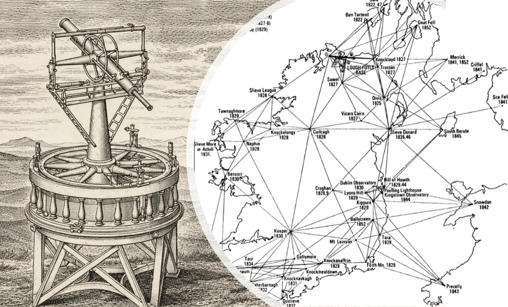
The Ordnance Survey, as it would become, is best known through its maps. These faithful cartographic works of art are admired and studied, analysed and debated, and their purpose sometimes questioned. Yet those maps rest on an invisible framework of measurements taken in difficult conditions by men who combined scientific thought, precise engineering and sustained physical effort.
Long before the first maps were drawn, in the early years of the nineteenth century, a small group of Royal Engineers and Sappers set out to measure the country from high on the mountains of Ireland. They climbed with instruments on their backs and built their camps on exposed summits. They waited, sometimes for weeks, for a break in the weather, and when it came, they measured angles across distances so great that the curvature of the earth itself became part of the problem. The surveyors left few visible marks– trig pillars came later. Instead, the fruit of their labour survived in the maps that followed, beautiful records of what they measured and helped make visible.
As well as providing the accurate framework for the map, the triangulation of Ireland formed part of a wider European endeavour to understand the shape of the earth. It also linked Ireland to Britain and beyond through shared methods, instruments and ideas that moved across borders as readily as the survey lines themselves. At the same time, the work remained firmly rooted in place: in the Glens of Antrim, the Mountains of Mournes and the hills of Donegal. These were not just abstract points in a geometric network, but physical markers in real landscapes, inhabited and weathered, and the surveyors who provided that framework experienced hardships, wind, rain and cold as they camped out on the mountain tops.
This chapter aims to bring that world into view. It is not only a story about the triangulation, which was the geometry that underpinned the Ordnance Survey, but also about the people who carried it out, the conditions they endured, and the ideas that shaped their work. It moves between the scale of the enterprise and the science that made it possible. It traces their experiences in the mountains, focusing on Thomas Drummond, one of the Ghosts of Mountjoy that I had encountered on my arrival in Ireland. [see here].
It is a story told in five parts, forming one chapter in the wider story about the Ordnance Survey in Ireland. If you are new to the story and want to follow from the start, see here.
Otherwise, read on.
18. On Exalted Hills
Measuring Ireland from the Summits
The opening post introduces the extraordinary project to measure an entire country using a network of triangles stretching from mountain to mountain and hill to hill. It reveals how the survey was linked to Britain, the scale of the distances involved, and the practical challenges of working across such vast lines of sight. It sets the scene for the mapping project unfolding on the highest ground across the country.
19. Inveterate Haze and Fogginess
Drummond and the Problem of Visibility
Ireland’s weather, the rain, the haze, the cloud and shifting light made it difficult to see from one summit to another. How that challenge was overcome through innovation is a tale about Thomas Drummond and his development of the limelight, a breakthrough that transformed long-distance observation, bringing national and international attention to the survey. The same invention that enabled long-distance surveying also gave rise to one of the most enduring metaphors for recognition and exposure. It is a story of the science behind the survey: precise, practical, and innovative.
→ Read Post 19 (To be published soon)
20. Into the limelight
From Divis to Donegal
On a remote mountain in Donegal, in the late autumn of 1825, the weather was broken and tempestuous. Drummond and his team attempted to establish a line of observation across sixty-seven miles to Divis Mountain near Belfast. Storms, isolation and uncertainty defied their efforts until, at last, the light was seen. Built around Drummond’s own words, this post captures the nature of the work and the experience of the survey from the inside.
→ Read Post 20 (Not yet published)
21. Endurance on the Edge
The Physical Labour of the Survey
Behind the scientific endeavour lay hard labour. This post broadens the focus to the wider body of surveyors. It tells of the men who carried instruments up mountains, built camps from stone and turf, and waited for the weather to clear. It explores the physical demands of the work and the resilience required to sustain it. The triangulation was both a scientific achievement and an act of endurance.
→ Read Post 21 (Not yet published)
22. From Limelight to Legacy
Thomas Drummond and the Duties of Power
“Property has its duties as well as its rights.”
Thomas Drummond’s career took him from scientific innovation into the heart of government in Ireland. As Under-Secretary at Dublin Castle, he became a reforming figure whose ideas still resonate. This final post reflects on his life and his work, and the legacy of the survey beyond measurement.
→ Read Post 22 (Not yet published)
Where to Go Next
- Explore earlier chapters: The Lough Foyle Baseline
- Follow the wider story: From Limelight to Satellite
Footnotes
[i] “Trig” is short for Trigonometric.
[ii] Similar remains have been found in Scotland linked with Colby’s triangulation work there at Creach Bheinn in Argyllshire (British National Grid reference NM 870 577) see: https://canmore.org.uk/site/23114/creach-bheinnThe Ordnance Survey is best known for its maps. Their faithful cartographic works of art are admired and studied, analysed and debated, their purpose sometimes questioned. These maps rest on an invisible framework of measurements taken in difficult conditions by men who combined scientific thought, precise engineering and sustained physical effort.
By subscribing, you will be notified of new posts.
