Surveying history under the stars: Why the Baseline is still important [i]
(Continued from the previous post: 15. Life Along The Line )
The baseline was more than simply a starting line. Only a few miles long, it became part of a global endeavour to measure the Earth itself.
Mapping Ireland
From mountain summits to hilltops to church towers, the baseline allowed the Ordnance Survey to construct its triangulation across Ireland. It allowed the whole island to be covered by a mesh of invisible triangles, creating the foundation for the entire national survey. Any error in the initial distance could have spread across the whole network. It was, as Thomas Colby wrote in 1826, “a very delicate operation on which the credit of the whole survey would greatly depend”. He was right.
From the principal triangulation, the systematic mapping of Ireland followed. From the large triangles, smaller ones were observed, forming a network of control points from which to survey townlands, roads, rivers, and settlements at a level of precision never previously achieved. The result was a detailed six-inch map that reshaped administration, taxation, engineering and land management. In parallel, the name books documented place-names, and the Memoirs captured the economic and cultural landscape, leaving behind a rich archive for historians, archaeologists, geographers and the culturally curious.
A Scientific Legacy
The Irish Principal Triangulation extended across the island and back across the Irish Sea and by the mid nineteenth century, a unified triangulation covered both islands.
Because the work had been carried out over many decades, the entire network required recalculation and adjustment. This enormous task was undertaken under the supervision of Alexander Ross Clarke, head of the Trigonometrical and Levelling Department of the Ordnance Survey and a team of human calculators, painstakingly combining decades of observations into one unified calculation. They organised, sorted and arranged the numbers, applied statistical methods to reconcile small discrepancies between observations, and by 1858, after seventy-five years of effort, the monumental task was completed. It was a mathematical and geodetic achievement that still stands as a highlight of nineteenth century scientific endeavour. From then on, the maps of Britain and Ireland stood on firm ground.
A European Tradition
The work at Lough Foyle did not take place in isolation. It formed part of a broader scientific movement that stretched across Europe during the late eighteenth and early nineteenth centuries. French geodesists such as Delambre and Méchain had demonstrated how precise baselines could anchor large national surveys, determine the metre and measure the size of the Earth. Thomas Colby and his colleagues were deeply influenced by this continental tradition. The techniques used on the Magilligan plain reflected and refined the same intellectual lineage that connected Paris, London, Bern, and Dublin, and in this sense, the Irish survey was part of a shared European effort to measure the shape of the Earth with increasing precision.
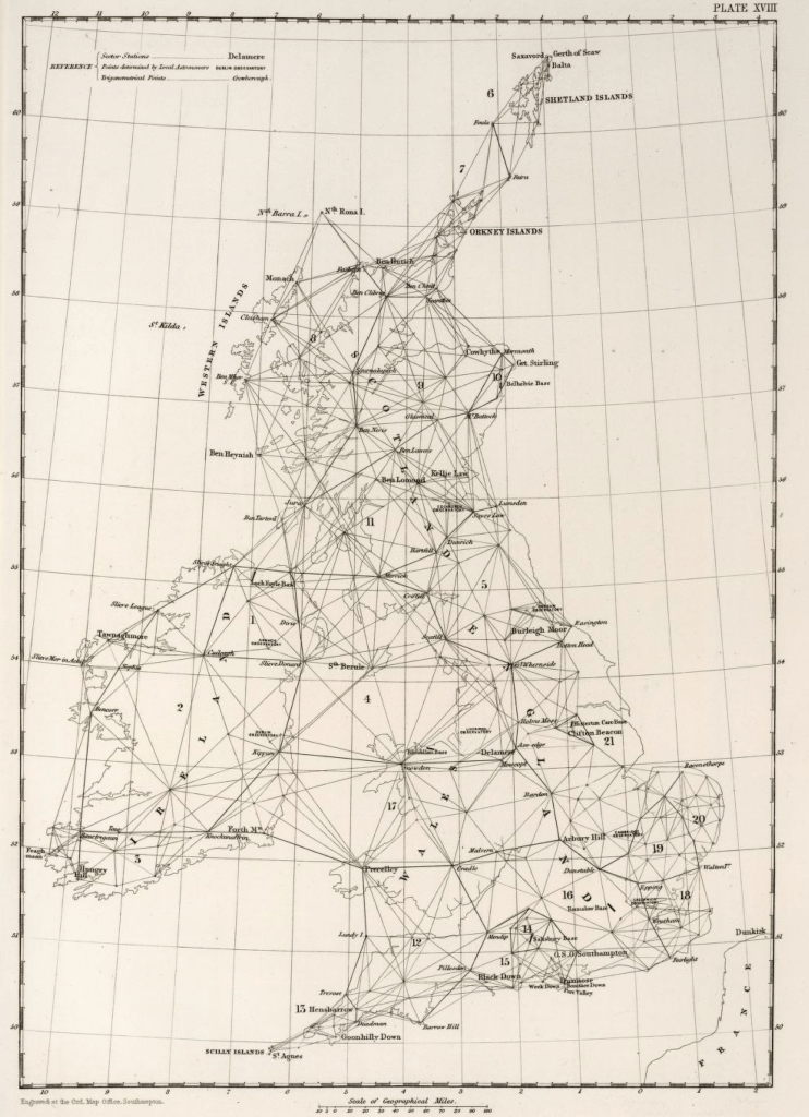
The Principal Triangulation of Great Britain and Ireland
Measuring the Earth
For centuries, scholars had attempted to determine the size and shape of the Earth. From Eratosthenes, the Greek scholar, through the triangulations of Willebrord Snellius and Jean Picard in the seventeenth century, measurement gradually replaced speculation. Isaac Newton argued that the Earth was not a perfect sphere but must bulge slightly at the equator because of its rotation. During the eighteenth century, French scientific expeditions confirmed his prediction by measuring arcs of the meridian in different parts of the world.
The triangulation of Britain and Ireland contributed to this international effort. Using positions derived from the network grounded in the Lough Foyle baseline, George Biddell Airy calculated a figure of the Earth that best fitted the British Isles. Known as the Airy Spheroid, it would remain the reference surface for mapping in Britain and Ireland for more than a century.
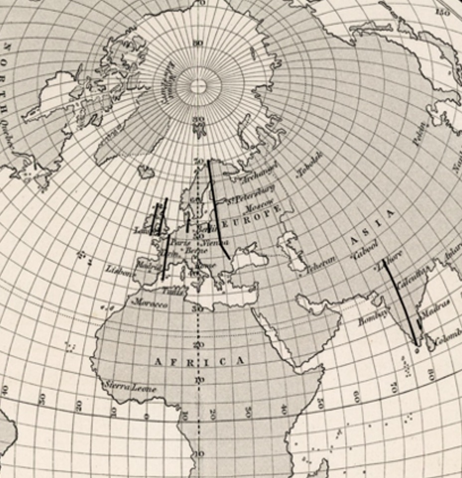
Later refinements by Alexander Ross Clarke incorporated measurements from other parts of the world, including India, Russia, and the Struve Geodetic Arc, which extends over 2,800 kilometres from northern Norway to the Black Sea. It consisted of a chain of triangulation points measured between 1816 and 1855 under the direction of Friedrich Georg Wilhelm Struve, and, just as in Ireland, depended upon carefully measured baselines, rigorous observation, and the coordination of work across difficult terrain. Now recognised as an UNESCO World Heritage Site, a transnational scientific monument, the Arc stands as an enduring example of international collaboration in geodesy, linking local measurements to a global understanding of the planet. Clarke used it and arcs in Britain and Ireland to develop figures of the Earth that became international standards adopted in many countries.
The measured line beside Lough Foyle formed part of this global scientific enterprise concerned with understanding the Earth’s shape and size. It helped confirm Sir Isaac Newton’s insight that the world is not an exact sphere. It helped to establish a more precise figure of the Earth and marked an important step in the development of earth sciences and topographic mapping.
Geometry and Time
The triangulation network, rooted in the Lough Foyle baseline, allowed surveyors to compare geometric measurements with astronomical observations.
Latitude had long been relatively straightforward, but longitude had remained elusive as it required accurate clocks. By the 1840s, chronometers had become sufficiently reliable for this comparison to be attempted. In 1844, thirty chronometers were transported from Greenwich to Valentia Island on the southwest coast of Ireland. The difference in local time between the two locations provided an astronomical determination of their difference in longitude. When this value was compared with the distance derived from triangulation, the results agreed within about one hundred feet, equivalent to roughly one-tenth of a second of time. It was a remarkable confirmation between geometry and time.
Retriangulation
The original Triangulation lasted for more than one-hundred years until the need for up-to-date maps created the opportunity to modernise it. In Britain, they fitted the new network to eleven of the original triangulation stations. The resulting coordinate system, known as OSGB36, based on Airy’s figure, still underpins the modern maps of Britain. In Ireland, retriangulations carried out in the 1950s and 1960s also reused old principal stations, on Slieve Donard, Divis, Trostan and Knocklayd. During this work, Colby’s baseline was remeasured using microwave equipment. The result differed from the 1827 value by only one inch. After more than a century, the precision of the original work had been confirmed.
From Baseline to Satellite
Just as the retriangulations in Britain and Ireland were underway, satellites were launched, blinking and beeping as they orbited the Earth. What began with optical observations and compensation bars evolved into Doppler tracking, then GPS, and ultimately into global reference systems used today. Satellite geodesy created entirely new ways of measuring the Earth.
Ireland adopted global reference systems during the 1990s, and in 2001, a new projection was introduced (the Irish Transverse Mercator projection) using the same mathematical model of the Earth used by satellite navigation systems (the GRS80 ellipsoid). Airy’s model of the Earth had stood for 171 years, and although the coordinates shifted, the intellectual continuity remained. The triangles that once stretched across mountains were now formed between the Earth and the orbits above it, yet still underpinned by networks of observations, rigorous adjustment, and traceable standards of measurement. Modern techniques differ in scale and method, not in principle.
Mapping Monuments
Today, the surviving baseline stations beneath Binevenagh have been described as “archaeology of cartography”. [ii] They are modest structures: circular enclosures protecting small chambers that mark the precise endpoints of the measured line. Yet they represent one of the most remarkable scientific undertakings of the nineteenth century.
Although Mount Sandy has long since been lost to the sea, the remaining stations still stand, protected monuments. They are understated markers of scientific ambition and scientific excellence. From these stones, distances were calculated to map every Irish coastline, headland and lighthouse. From these distances, arcs of meridian were derived. From those arcs, spheroids were calculated. And from those spheroids, the coordinate systems that structured modern mapping were born.
Few monuments illustrate so clearly the connection between local measurement and global science. The baseline matters because it links a quiet, windswept shore next to Lough Foyle to a wider history of humanity’s efforts to measure and understand the Earth.
Sources and References
[i] This article is based on the following:
- Presentations given by the author at the Ordnance Surveys in Dublin, Belfast and at the Drummond Hotel in Ballykelly to mark the 200th anniversary of the Ordnance Survey arriving in Ireland;
- A paper written by the author in support of the Mapping Monuments Project, a community heritage project led by the Causeway Coast & Glens Heritage Trust and Queen’s University Belfast. The assistance of Professor Keith Lilley is gratefully acknowledged;
- “An Account of the Measurement of Lough Foyle Base with its verification and extension by Triangulation”, by Captain William Yolland, Board of Ordnance, 1847;
- “Account of the Observations and Calculation of the Principal Triangulation” (and of the Figure, Dimensions and mean specific gravity of the Earth as derived therefrom)”, drawn up by Captain Alexander Ross Clarke RE FRAS under the direction of Lt Colonel H James, RE FRS MRIA &c., Superintendent of the Ordnance Survey. Published by George Edward Syre and William Spottiswoode, 1858;
- “Early Years of the Ordnance Survey” Colonel Sir Charles Close, Institution of Royal Engineers, 1926.
[ii] “Surveying Empires: Archaeology of Colonial Cartography and the Great Trigonometrical Survey of India.” Keith D. Lilley, 2020.
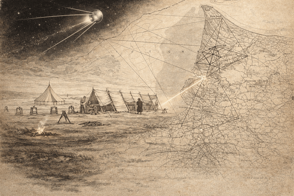
Header Image created using AI. The other images come from the “Account of the … Principal Triangulation”, 1858.
By subscribing, you will be notified of new posts.
