The measurement of the baseline.
(Continued from the previous post: 13. To Colby The Design …. )
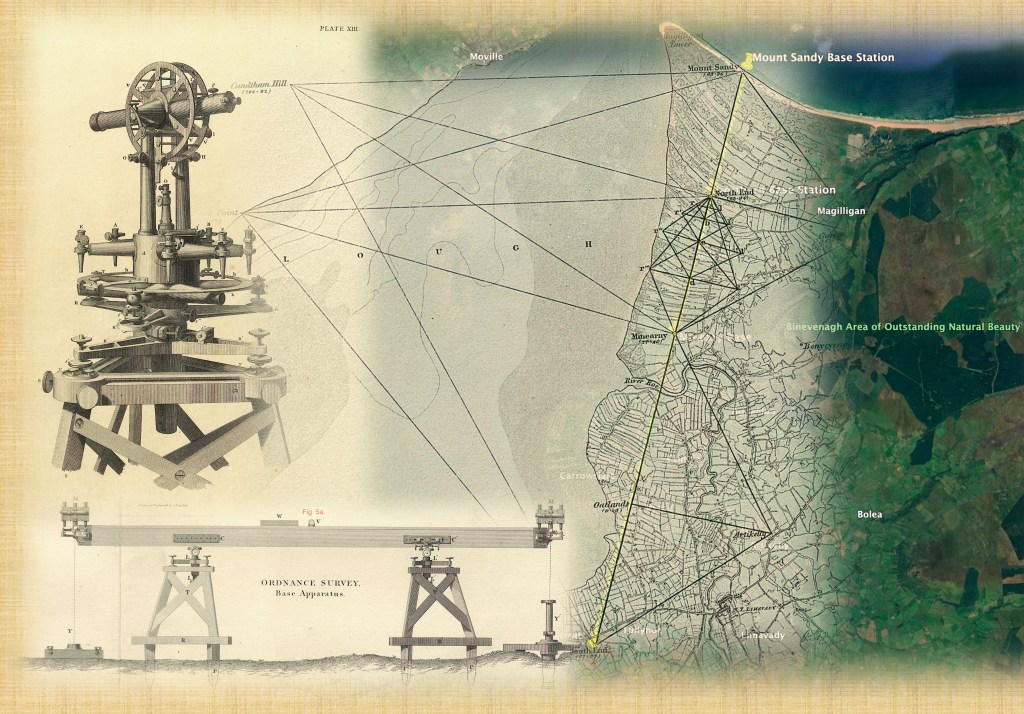
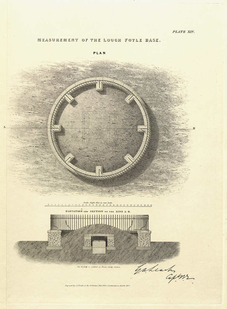
Four baseline stations were laid out along the plain by Lough Foyle. The North End and South End stations marked the start and end points. Minearny Station was the third, about a quarter of the way between them, just north of the River Roe. The final point, Mount Sandy, was located in the dunes to the north, next to Benone Strand. These survey points were protected from disturbance by an earth mound covering a chamber, surrounded by a circular, two-foot-thick wall 30 feet in diameter, topped with iron railings. The Board of Ordnance purchased the land to ensure the points would remain protected and available for future use. Work on building and marking the stations was completed by the third week of August 1827, allowing preliminary angle observations to be made from the hills and mountains surrounding the baseline, connecting it into the triangulation.
The Base Station construction.
Source: “An Account of the Measurement of Lough Foyle Base with its verification and extension by Triangulation”, by Captain William Yolland, Board of Ordnance, 1847
Work on measuring the line began on the 6th of September 1827 from the North End station. Measurement headed south, with each wooden box containing Colby’s bars aligned precisely by theodolites. Boards were placed at regular intervals to guide intermediate markers. All six compensation bars were placed end to end, precisely six inches apart, on supporting trestles over pickets driven into the ground, keeping them level over the undulating terrain. Fine adjustments were made using spirit levels.
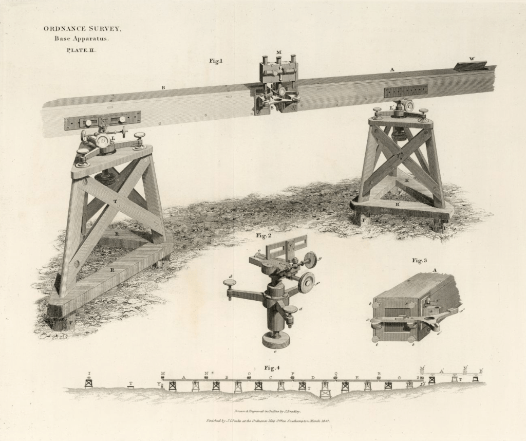
A detachment of Sappers under two sergeants of between six and twenty-three men was employed on the measurement. They looked after the camp, the placement of the triangular frames, pickets, trestles, and alignment of the bars. A non-commissioned officer adjusted the screws; another recorded the observations; another attended to the setting of the rollers and the regulation of the plates; and a fourth, with a few men, erected the base tents, moving them forward to the succeeding series of bars, and looking to the security of the apparatus at night. Drummond or Colby oversaw the whole exercise.
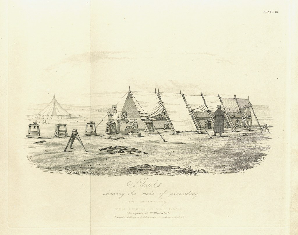
Mode of Proceeding: A contemporary Sketch, possibly by Herschel, showing the baseline being measured.
Work stopped in October for the winter and resumed the following July.
In the second year, the crossing of the 450-foot-wide River Roe was a particular challenge. Sergeant Thomas Sim of the Corps of Sappers and Miners proposed the method to be used. Stout pickets were driven into the sand and clay of the riverbed to a depth of about six feet. The bars were placed on horizontal stretchers over the trestles, and the men had to wade across, making precise adjustments in level and alignment. The bars were just six inches above the water line at high tide. The crossing was completed in one day and verified by a repeat measurement the following day. [4]
By the 20th of November 1828, after a short pause to allow the crops to be harvested, the whole baseline measurement was completed.
True to Colby’s expectations, the pursuit of accuracy and the avoidance of error were paramount. Different officers made double measurements, such as across the River Roe, or if the bars were disturbed by man, wind or even excessive sunshine. Sir John Herschel, President of the Royal Astronomical Society and Charles Babbage were present at one remeasurement and “expressed themselves much pleased with the near coincidence of the two measurements”.[5]
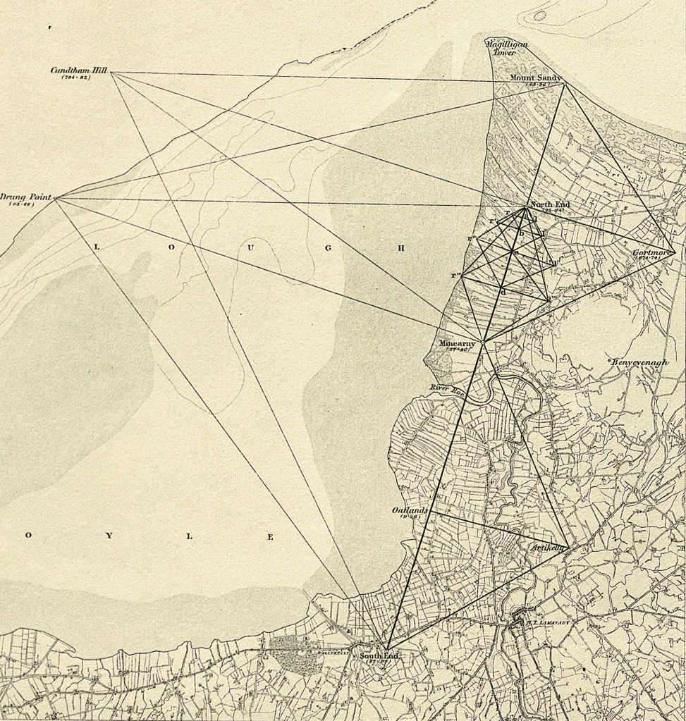
The baseline was also verified by a small comparative triangulation scheme (pictured) established in its immediate vicinity and observed by Drummond. This allowed the baseline to be split into several sections so that one part of the base could be calculated through the triangulation from another part, and then compared to its distance as measured with the bars. Using the triangulation, the baseline was extended to Mount Sandy station, and the distance from the North End to Mount Sandy was calculated through eight triangles. The distance thus calculated agreed to within one centimetre over the 3.5 km distance. [6]
When complete The Lough Foyle baseline was found to be 41,640.9228 feet long (12.692 km), a distance reduced by 0.03555 feet (11 mm) to sea level.
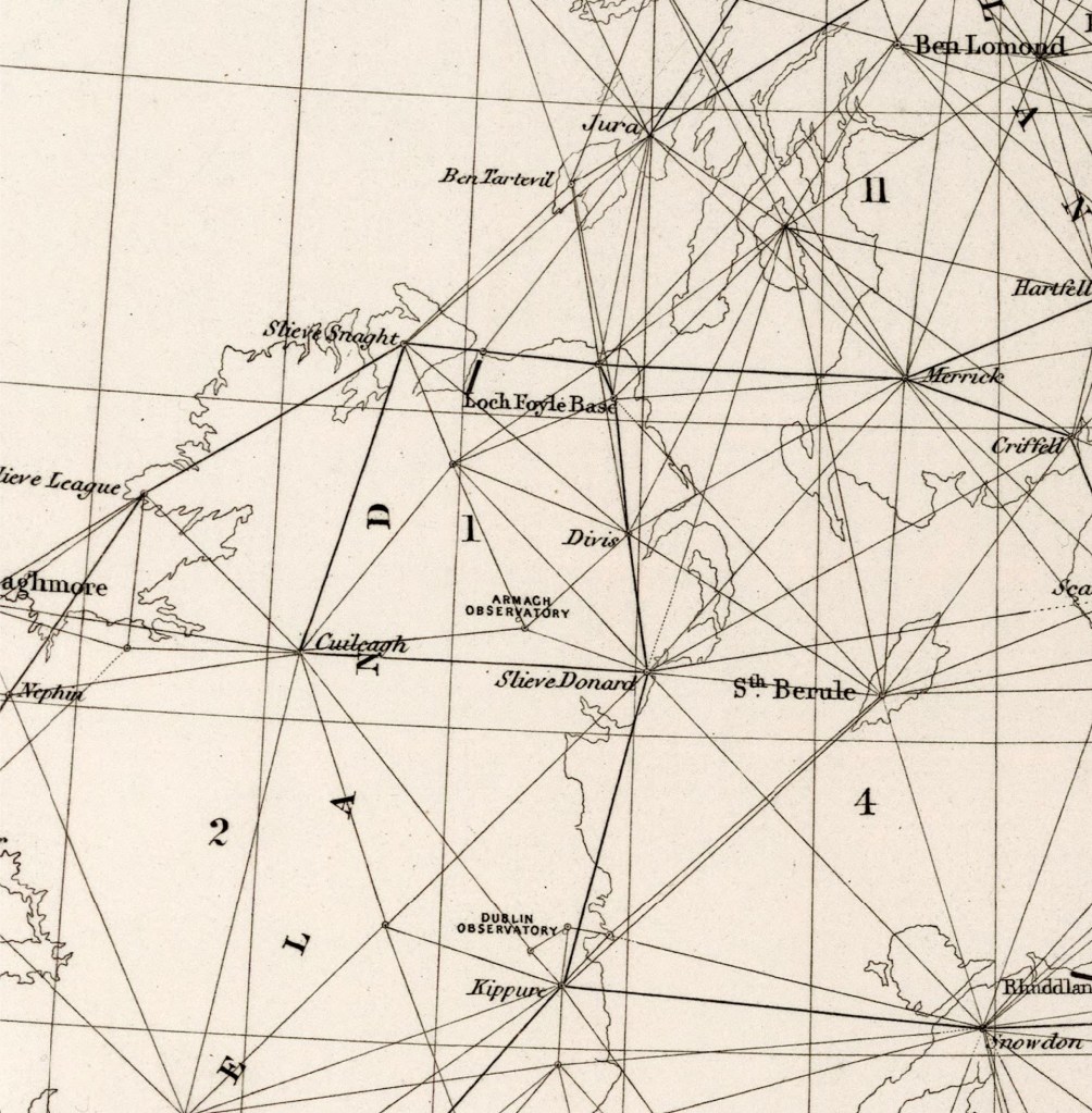
As the purpose of the baseline was to provide scale and distance for the whole triangulation scheme, it was necessary to connect its ends accurately by angular observations to the Principal Triangulation stations already sited on the hills and mountains surrounding the plain. The North End, South End and Mount Sandy stations were thus connected to trigonometric points on the Scottish mountains on the Isles of Jura and Islay and the Irish mountains at Slieve Snaght, Sawel and Knocklayd. The angles of the triangulation were urgently required for the interior survey, so the officers and men of the Survey camped out on the mountains, even during the winter months of 1827 and 1828, to get it done. By the summer of 1829, all the work at the baseline was complete. (Although, some additional angle observations were made 20 years later, in 1849, when Mount Sandy was observed from the Isle of Jura).
Establishing the work in Ireland had taken some time, and Colby was under significant pressure to make progress, with criticisms and complaints about the speed of his methods even reaching the ears of Lord Wellington, who was by now Prime Minister. [7] It isn’t surprising that Colby was too busy to write up his work. Drummond was called away early when falling out with Colby in the 1830s, to undertake political duties, first on the Boundary Commission required as a result of the Representation of the People (Ireland) Act 1832, then as Private Secretary to Lord Althrop, and finally as Under- Secretary in Ireland from 1835 to until Drummond’s early death in 1840; Murphy, also active in the base measurement, was called to lead the scientific operation of the Euphrates Expedition. No contemporary account exists of the measurement.
Colby’s character fault, according to Portlock, was that he thought little of personal distinction, focussing instead on the work of the Survey and the publication of its maps, rather than the publication of scientific papers. Thus, his work was in danger of “fading away into oblivion”. Fortunately, it was witnessed and recorded by too many eminent scientists to do so. Word of its achievements spread widely and quickly. Sir George Everest was in England in 1829 recovering from illness, studying Colby’s methods, and ordering the same bars from Troughton and Sims for use on the Survey of India. Similarly, the Astronomer at Cape Town, McClear, used it on the measurement of the first base in Africa, which would be observed by Captain Henderson, who had been employed on the Lough Foyle Base.
Salisbury Plain Remeasurement
No other baselines were measured in Ireland.
The other baselines in Great Britain, when calculated from Lough Foyle through the triangulation connecting the two islands, were found to be materially inaccurate for use in the Triangulation. The original measurement of the Salisbury Plain baseline in 1794 had used steel chains and could not be reproduced to sufficient accuracy from the Lough Foyle Baseline. So, in 1849, it was decided to remeasure it using Colby’s Compensating Bars. This was under the direction of Captain Yolland and carried out by Sergeant Steel, and a party of Royal Sappers and Miners using the same method as in Lough Foyle. The only change made was that the number of comparisons undertaken to calibrate the six-inch gap between the bars was increased to improve that part of the Salisbury Plain measurement.
The canons marking the ends of the Salisbury baseline were found to be intact. As the North End, three miles west of Aylesbury on Beacon Hill, and the South End, near Old Sarum Castle, 1 ½ miles from Salisbury, were not intervisible, a theodolite at the south end was elevated on a tower above the mark to keep the bars aligned. The elevation of the theodolite at the south end caused some difficulty, as did the 11-degree slope at the north end, but the baseline was remeasured satisfactorily and found to be 36,577.8581 feet when reduced to mean sea level (a reduction of -0.6294 feet). It is reported that the end points are still there: the south end is buried in undergrowth, and the north end is under a triangulation pillar built over it in 1936. Both now have listed monument status by English Heritage.
Four other baselines in Great Britain, originally measured with Ramsden’s 100-foot steel chain, were used as a verification of the Principal Triangulation. One, Rhuddlan Marsh in Wales, was rejected as it was in an unfavourable position with a difference of 1.596 feet from the computed distance. The greatest difference between computed lengths and measured lengths of the others was 3 inches, providing the verification required.
The two baselines at Lough Foyle (7.89 miles) and Salisbury Plain (6.93 miles) were used as the basis of all trigonometrical distances calculated in the Principal Triangulation. This was finalised once all the observations had been completed, and the results were published in 1858. The difference between the measured lengths and their lengths computed through the triangulation is +/- 0.4178 feet, or about 5 inches. This difference was divided in proportion to the square root of the lengths of the measured bases, from which was obtained the mean base, used in the final results of the trigonometric calculation. There is a final difference of +/- 0.2 feet, or 2 ½ inches, between the measured and computed length of the bases.
The Baseline Today
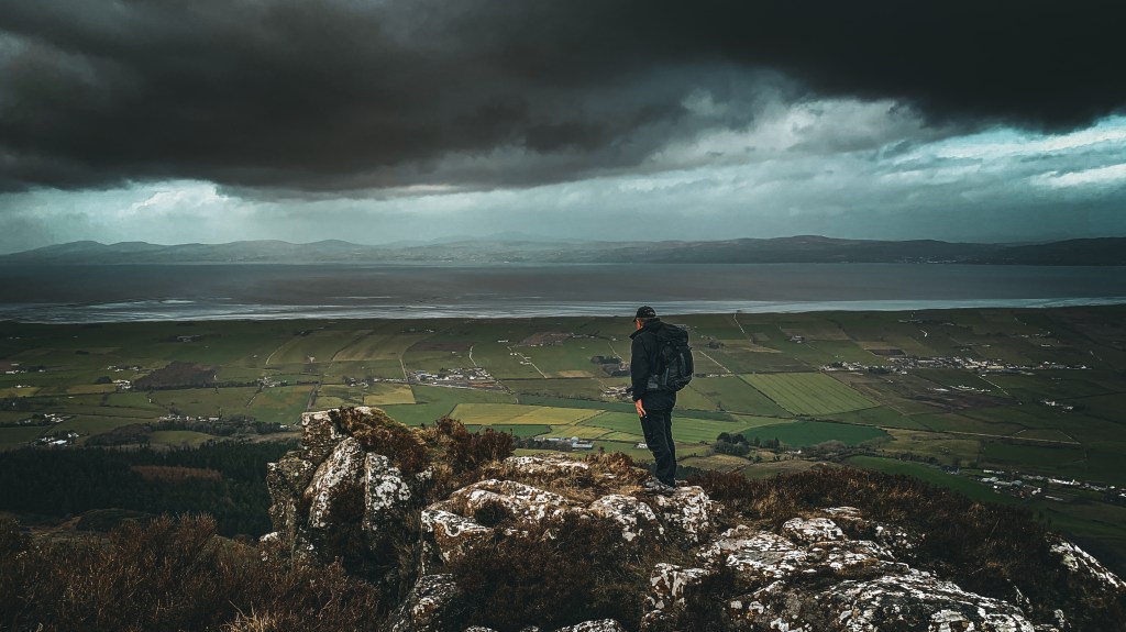
Looking from the top of Binevenagh cliffs, across the plain to Lough Foyle and Donegal in the distance.
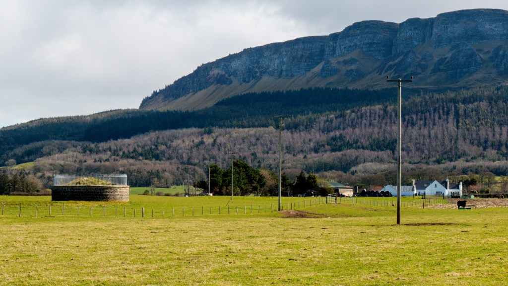
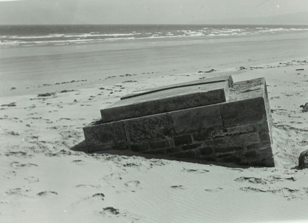
The South Station, Minearny and North Station still stand today, protected monuments.
The Mount Sandy Station was washed away in the late 1950s as a result of coastal erosion.
Where are the Bars?
The bars used on Lough Foyle were sent to South Africa in 1839, where Captain Henderson, who had worked for Colby at Lough Foyle, measured the first baseline in Africa for the Astronomer at Cape Town, Thomas Maclear. They then made their way to Southampton in 1841 and were used again in 1849 to remeasure the Salisbury Plain baseline in England. They remained in England until November 1923, when one was returned to Ireland following a request by the Free State Government. [8] It now resides at the Tailte Éireann mapping offices in Phoenix Park, the former headquarters of the Ordnance Survey Ireland. Another, on loan from the Greenwich Museum, was, until recently, on display at the Tower Museum in Derry. A third is held by the Ordnance Survey in Southampton.
Next Week: Along The Line: Life along the baseline in 1830.
Booklet
The following booklet, available for download, describes the baseline and its measurement.
Notes:
This Blog and the pictures used is based on several sources:
- “Memoir of the Life of Major-General Colby” by Lt. Col. J.E. Portlock, Seeley, Jackson & Halliday 1869;
- “An Account of the Measurement of Lough Foyle Base with its verification and extension by Triangulation”, by Captain William Yolland, Board of Ordnance, 1847
- “Account of the Observations and Calculation of the Principal Triangulation” (and of the Figure, Dimensions and mean specific gravity of the Earth as derived therefrom)”, drawn up by Captain Alexander Ross Clarke RE FRAS under the direction of Lt Colonel H James, RE FRS MRIA &c., Superintendent of the Ordnance Survey. Published by George Edward Syre and William Spottiswoode, 1858;
- “Early Years of the Ordnance Survey” Colonel Sir Charles Close, Institution of Royal Engineers, 1926;
Footnotes
[1] Based on the story told by Portlock in his book “Memoir of the life of Major-General Colby”, Seeley Jackson & Halliday, 1869.
[2] “To Colby the design, to Drummond the execution” is a quote attributed to Larcom in “Thomas Drummond – Life and Letters” by R Barry O’Brien, p 57, and noted by John Andrews in his book “A Paper Landscape”, Oxford University Press, 1975.
[3] Letter from Drummond’s papers quoted by Close, page 115.
[4] History of the Royal Sappers and Miners, Vol 1 p274 Project Gutenberg: https://www.gutenberg.org/files/55776/55776-h/55776-h.htm accessed 6/2/2024.
[5] Yolland, page 28.
[6] 0.031 foot (less than 0.4 of an inch) over its accepted distance of 11,559.8270 feet.
[7] Wellington wrote to Lord Anglesey on 30th March 1828, instigating an inquiry into progress of the Survey, and this ultimately led to Colby being sent to Ireland to personally oversee the work there. PRONI.
[8] Correspondence NAI, TAOIS/S 5043A.
By subscribing, you will be notified of new posts.
