The surveyor whose drive, determination and insistence on accuracy left a durable and long-lasting mark on the Ordnance Survey.
For more than a quarter of a century, Thomas Colby shaped what became the Ordnance Survey. In doing so, he imposed on it the habits of rigour, discipline and accuracy that outlived him by generations. Nowhere were those qualities more fully expressed than in Ireland, where his insistence on precision produced a map of unprecedented scale and reliability, devising a system to produce it that remained visible almost two centuries later. [1]
He cut an unconventional figure. Slightly eccentric in dress and manner, and restless in movement, he possessed what contemporaries described as a nervous, elastic frame that seemed impervious to fatigue. His private life, such as it was, was conducted at speed. He strode everywhere with purpose and energy, whether climbing the mountains of Scotland and Ireland or through the streets of London. A man with an appetite for food and science, he was seen more often running than walking to attend the many scientific and literary societies as a bachelor in London, inviting his officers to “Come to the lecture at the London Institution and let us have some chop by the way”, or “to come back my boy and take a beefsteak with me”, which often expanded to an “excellent fish and a good fat Turkey”.
A firearms accident in 1803 had cost Colby his left hand and left a permanent scar on his forehead. Portlock, his biographer, records that his recovery was widely regarded as improbable at the time. Yet he did recover, and the accident became a defining episode in how contemporaries understood him, and thereafter he seemed to take a perverse satisfaction in proving that physical impairment need not diminish scientific precision. It helped define his own approach to what would become his life’s work, the Ordnance Survey.
Colby was trained at the Royal Military Academy, Woolwich, where he learned surveying as a practical craft rather than an abstract science. Commissioned into the Royal Engineers at seventeen, he was attached in 1802 to the Trigonometrical Survey at the request of William Mudge, its Superintendent, possibly aided by family connections. [2] He was the first Royal Engineer to be permanently assigned to the Survey, establishing a precedent that all future military directors would follow. Mudge quickly recognised a kindred spirit and made Colby his personal assistant. Portlock later remarked that Colby’s habits of mind were already fixed by this stage, methodical, exacting, and intolerant of carelessness.
Following Mudge’s death, Colby was appointed by the Duke of Wellington as Superintendent at the age of 36. Administrative oversight from the Tower of London did not suit him. He preferred mountains to offices and continued to work in the field, particularly in Scotland, where he undertook arduous reconnaissance marches in advance of the triangulation. He would spend weeks on exposed summits, waiting for the weather to clear, selecting stations, and sharing the labour of his men. Portlock observed that even when on top of mountains, he was seemingly unaffected by the bitter blast of winter, “as much at home there as in comfortable winter quarters”.
As a leader, Colby was exacting and frequently combative. He reacted defensively to criticism and did not hesitate to remove officers who challenged his authority, even long-standing collaborators. Colby’s defensive reaction to challenge led to the departure of several able officers, men who might otherwise have succeeded him. Some of these able men, including Drummond and Larcom, would move on to excel in other posts. In the early days of the Irish Survey, Major Reid had been put in charge at Dublin and employed civilian surveyors in Colby’s absence to accelerate progress, offending Colby’s preference for a wholly military organisation. Although displeased, Colby accepted the arrangement provided that civilian work was tightly supervised by military officers. The hybrid workforce that emerged became the model for the Survey thereafter, and would continue until 1977 in Britain and 1994 in Ireland. Colby did not forget, and Reid would be moved on shortly afterwards. Yet even Colby’s critics acknowledged his personal kindness. In personal dealings, Colby could be generous, paternal, and deeply concerned for the welfare of his men, working alongside them, helping raise stations and shelters, and marking the completion of hard tasks with generous feasts.
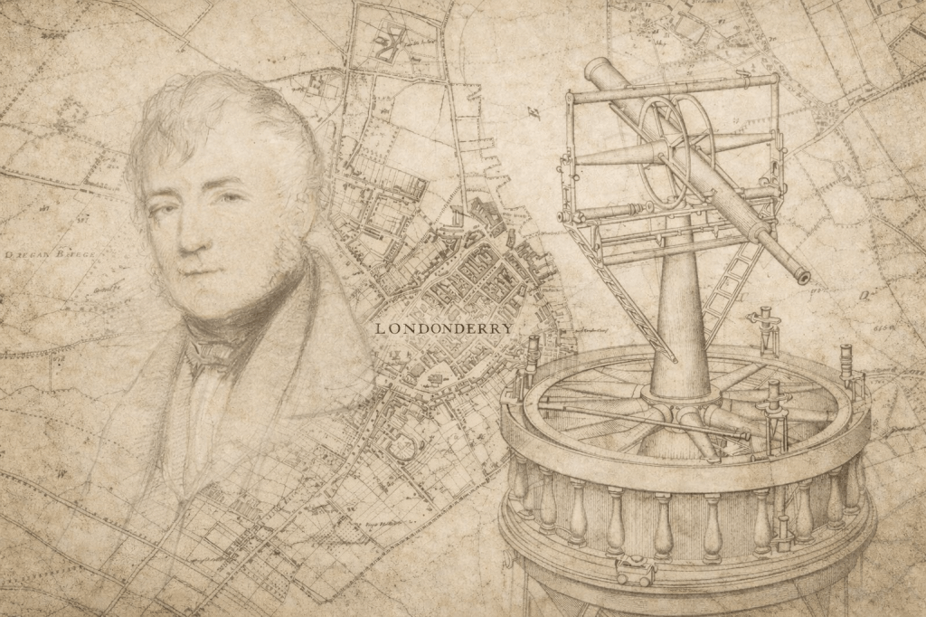
Colby took direct charge of the Irish Survey in 1828, moving to Dublin. He married Elizabeth Hester Boyd, daughter of the late Archibald Boyd, Treasurer of the City of Londonderry. They settled at Knockmaroon Lodge near the Phoenix Park, where they raised a family of four sons and three daughters. Under his direction, Ireland was completely mapped at six inches to the mile, the first country to be mapped in such detail. The methods he devised, most notably the compensation bars used to measure the Lough Foyle base, reflected his belief that accuracy justified delay, cost and inconvenience. The resulting maps were not merely instruments of administration but, as he himself foresaw, records for generations to come.
He returned to England as the Irish work drew to a close, relocating the Survey’s headquarters from the Tower of London to Southampton after a fire, and remained there until his retirement in 1846 as a Major-General, the longest-serving head of the Ordnance Survey. He cared little for honours or wealth, focusing instead on the work of the Survey, preferring that the maps speak for themselves.
When Colby died in 1852, Sir George Airy said, “I was often struck with the peculiar adaptation of Colonel Colby’s talents and habits to the great work which he directed and the great system which he principally created…. And all this devotion of himself to this great work appeared to be wholly unselfish”. [3]
[1] This profile is based on the following sources:
- “OBITUARY. Major-General Thomas F. Colby, 1784 – 1852” Minutes of Proceedings of the Institution of Civil Engineers, Volume 12 (1853), pp. 132–137.
- “Memoir of the life of Major General Colby”, Lt. Colonel J.E. Portlock; Shelley, Jackson & Halliday, 1869.
- “A Paper Landscape, The Ordnance Survey in Nineteenth-Century Ireland”, J.H. Andrews, Oxford at the Clarendon Press, 1975.
[2] Colby’s uncle was General Hadden, the Surveyor General of the Board of Ordnance
[3] Sir George Airy writing to the Elizabeth Colby in 1869.
By subscribing, you will be notified of new posts.
