Longitude, navigation, and the consequences of being in the wrong place.
“Farewell and Adieu to You, Spanish Ladies.”
“We’ll rant and we’ll roar, like true British sailors,
We’ll rant and we’ll roar across the salt seas;
Until we strike soundings
In the Channel of old England,
From Ushant to Scilly ’tis thirty-five leagues.
Then we hove our ship to, with the wind at the sou’west, my boys,
Then we hove our ship to, for to strike soundings clear;
Then we filled the main topsail
And bore right away, my boys,
And straight up the Channel of old England did steer. [1]
Few sea songs carry such quiet menace as “Farewell and Adieu to You, Spanish Ladies.” Sung by sailors leaving Spanish ports and steering north for home, it is a song of nostalgia and fear. Nostalgia for exotic foreign shores, and the fear of navigational unknowns.
It traces the western approaches to the English Channel, naming headlands and islands that every mariner feared and watched out for. In the prevailing south-westerly winds, ships heading home had to find the entrance of the English Channel, avoiding the French headland of Ushant to the east, and the Scilly Isles to the north. Among them, the Isles of Scilly loom largest, not for their size, but for the consequences of navigational error.
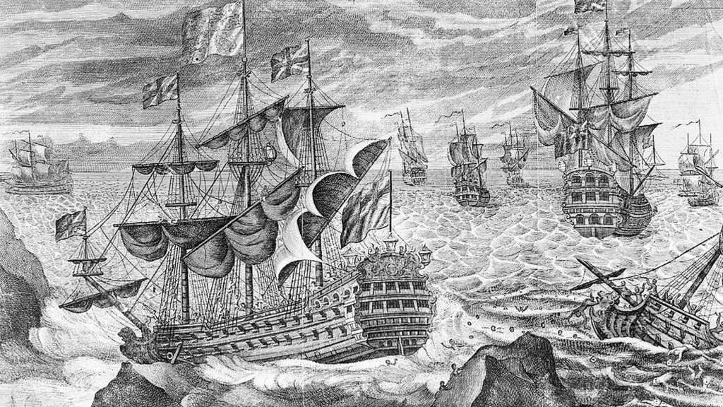
Nearly 320 years ago, on a wild October night in 1707, twenty ships of the Royal Navy were sailing home from the Mediterranean under Sir Cloudesley Shovell, an Admiral of the Fleet. Shovell was no novice; he was experienced, confident, and famously intolerant of dissent. According to some accounts, he ordered a sailor hanged when he had dared to question his navigational ability.
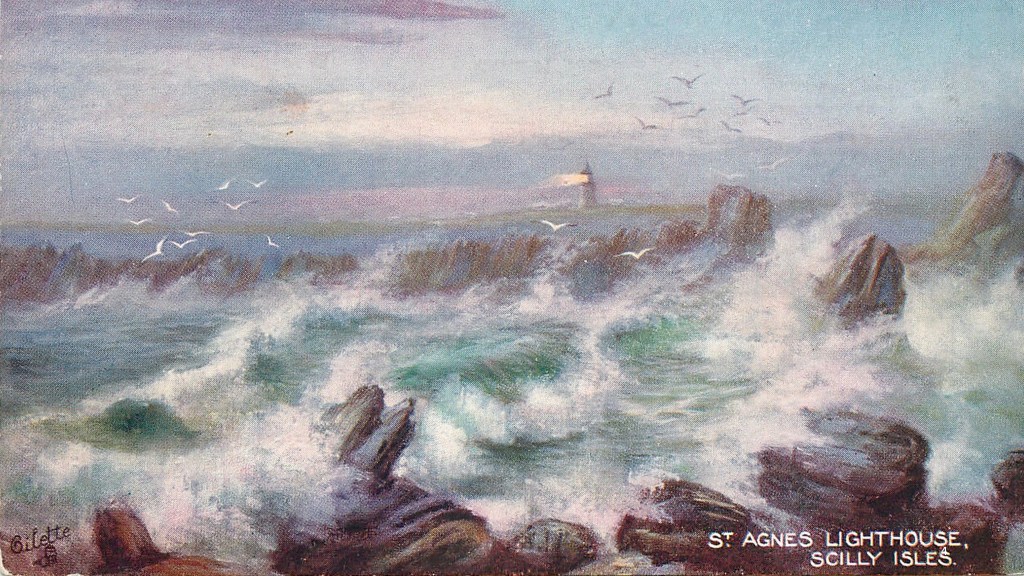
At about eight o’clock in the evening on the 22nd of October, the crews of several of Shovell’s ships glimpsed rocks through the spray, and the faint light of St Agnes in the Isles of Scilly. Warning guns were fired, but too late. Four ships struck and foundered, and Shovell and around 2,000 of his men drowned. It remains one of the worst and most consequential maritime disasters in British history.
Whilst navigational error and human hubris were the likely causes, there was a deeper, systemic failure involved. The fleet had believed it was safely in the Channel, yet in reality, it was still too far to the west. The Isles of Scilly were not where the charts said they were.
By the late eighteenth century, this uncomfortable truth could finally be tested. A chain of triangulation, observed by the Board of Ordnance, had progressed westward from Greenwich to Cornwall and then out to the Scillies. For the first time, the position of the islands could be fixed geometrically rather than assumed astronomically. [2] Independently, the hydrographer Joseph Huddart had carried a marine chronometer to St Mary’s and compared local solar time with Greenwich time. [3] Both methods agreed.
The error was stark. The accepted longitude of the Isles of Scilly was wrong by about 26 minutes of arc, equivalent to an astonishing 32 kilometres. [4] The fleet of 1707 had not misjudged its course by a little but had made a monumental misjudgement based on wrong information. An empire built on sea power did not, in fact, know the true positions of its own coasts, headlands, and lighthouses.
*****
Triangulation
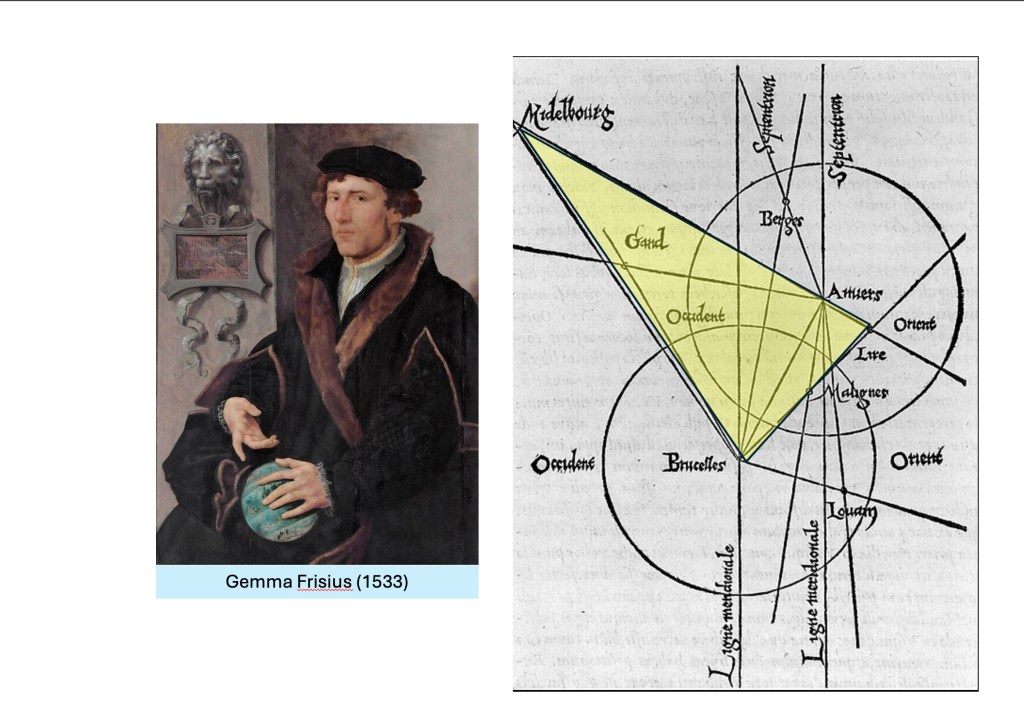
Gemma Frisius, Mercator’s teacher at the University of Leuven in modern-day Belgium, described the concept of triangulation in 1533. It was, he said, a method “very useful and profitable for all geographers, teaching how to measure and compute the distance between two places which was never seen.” The principle was simple: if you measure one side and all the angles of a triangle, you can calculate the lengths of all the other sides using trigonometry. By extending a series of interlocking triangles across long distances over the land, the unknown distance between two points could be measured.
Tycho Brahe developed the method further. He is remembered for his false nose made from gold and silver, which he lost in a duel over a mathematical disagreement with another. But he also used triangulation to locate his castle and observatory in the Oresund, between Sweden and Denmark, and as a framework for a cadastral survey of his island.
Working in the Dutch Republic in the early seventeenth century, Willebrord Snell developed the concept even further. He measured a chain of triangles between Alkmaar and Bergen op Zoom, starting at one baseline and then measuring the angles of the triangles, then calculating distances from these rather than from direct ground measurement alone. This allowed him to estimate the size of the Earth, demonstrating that large-scale measurement could be achieved by combining geometry, astronomy, and carefully controlled observation. [5]
Snell’s principles were refined in France by the Cassini family, which spent eighty years extending a triangulation to create a framework for their map of France, and to help measure the size of the Earth. It was completed by the end of the 18th century at the scale of 1:86,400, changing the known outline of France. The third Cassini, Count Cassini de Thury, wrote a memoir to the British, suggesting that Greenwich was in the wrong place. He offered to collaborate on a triangulation to determine “la difference” in Longitude between Greenwich and Paris, connecting Britain to the rest of Europe in the interests and advancement of science. [6]
Britain accepted the challenge.
[1] “Farewell and Adieu to You, Spanish Ladies” or Spanish Ladies is a traditional British naval sea song, sung by sailors leaving Spanish ports and heading home to England, with navigational references. Before reliable longitude could be determined by a chronometer, mariners relied on lead-line soundings to fix their position when approaching the English Channel. A weighted lead, marked at regular intervals, was lowered to the seabed to measure depth, while tallow in a hollow at its base brought up a sample of the bottom. Distinctive combinations of depth and seabed type—sand, gravel, shell, or mud—were compared with printed sailing directions and charts. Particular banks and depth contours in the western approaches acted as natural “underwater signposts,” allowing ships to recognise when they had reached the correct latitude and distance off the coast at which it was safe to turn east into the Channel, even when their east–west position remained uncertain.
[2] William Mudge, An Account of the Trigonometrical Survey, carried on in the Years 1797, 1798, and 1799, Philosophical Transactions of the Royal Society of London, vol. 90 (1800), esp. Section II, where the Isles of Scilly are connected by triangulation to the meridian of Greenwich via St Agnes Beacon. He states in the Introduction to this paper that the purpose of the Trigonometrical Survey was the determination of the correct positions of headlands, coastal features, and remarkable objects rather than the production of a general map.
[3] Mudge, Trigonometrical Survey (1800), reporting the observations of Joseph Huddart, who carried an Arnold chronometer to St Mary’s, Scilly, and determined longitude by equal altitudes of the Sun, explicitly referencing the spot where Shovell’s body was said to have come ashore.
[4] Mudge (1800) compares the Ordnance Survey longitude of the Scilly Lights (6° 19′ 23″ W) with the value published in the Board of Longitude’s Requisite Tables (6° 46′ 00″ W), identifying an error of 26′ 37″—equivalent to 1 minute 46 seconds of time, or roughly 32 km at that latitude.
[5] N. D. Haasbroek, Gemma Frisius, Tycho Brahe and Snellius And their triangulations (Rijkscommissie Voor Geodesie, Kanaalweg 4, Delft, Netherlands) 1968.
[6] Colonel Sir Charles Close, The Early Years of the Ordnance Survey, (Institution of Royal Engineers), 1926.
By subscribing, you will be notified of new posts.

Response
[…] story unfolds in three stages: Disaster at sea near the “Isles of Scilly” led to a realisation that the location of the coasts of Britain was largely unknown; then […]
LikeLike