Paris and Greenwich, science and rivalry, and the measurement of position. The Great Trigonometric Survey of Britain and Ireland begins.
A late-eighteenth-century scientific dispute between Paris and Greenwich seems remote from Ireland. Yet an argument over just a few seconds of latitude and longitude created the scientific, institutional, and political conditions that eventually brought Ireland into a new European framework of measurement and onto a map drawn with unprecedented accuracy.
By the 1780s, the Cassinis had built a vast triangulation network across continental Europe, linking France to Holland and extending eastwards towards Vienna. In 1783, Cassini de Thury, Director of the Paris Observatory, wrote a memoir to the British government arguing that, “for the progress of astronomy“, it was essential to establish “la différence”, or the precise positional relationship between the Paris and Greenwich observatories. He suggested, pointedly, that Greenwich itself might be misplaced by several seconds. Astronomers, following the Cassini tradition, had determined the difference in longitude between the Royal Observatory, Greenwich and the Paris Observatory by observing eclipses and the satellites of Jupiter. The accepted value was approximately 9 minutes 30 seconds of time. [1]
The proposal appealed directly to George III’s scientific interests and was referred to the Royal Society. But while framed as an astronomical problem, it carried wider implications. Connecting Paris and Greenwich by measurement would link Britain into the European scientific system already established. Once that connection existed, the question naturally followed: how far could it be extended?
The Royal Society appointed William Roy to lead the work on the British side. William Roy had completed a military map of Scotland for the Board of Ordnance following the Jacobite Rebellion of 1745, the idea of Lieutenant Colonel David Watson of the Engineers, and with the agreement of George II. He had developed his scientific approach to map-making and was convinced that Britain required a systematic national survey. His earlier proposals had been rejected as too costly, but Roy understood this new project was not simply about observatories; it was an opportunity to establish a precise geometric framework across the islands of Britain, and beyond.
National pride, along with political, scientific and practical arguments, contributed to an agreement to undertake the work with the French. The King wanted it and took a personal interest in the work, paying for the instrumentation. The Royal Society wanted it to further scientific understanding, and the Astronomer Royal, Dr. Maskelyne, an influential member, wanted it too, as he had observed Greenwich’s position “without the error of a single second”. No doubt he wished to prove it. William Roy saw it as the means to progress a national map. The Paris–Greenwich problem offered a politically acceptable starting point. [2]
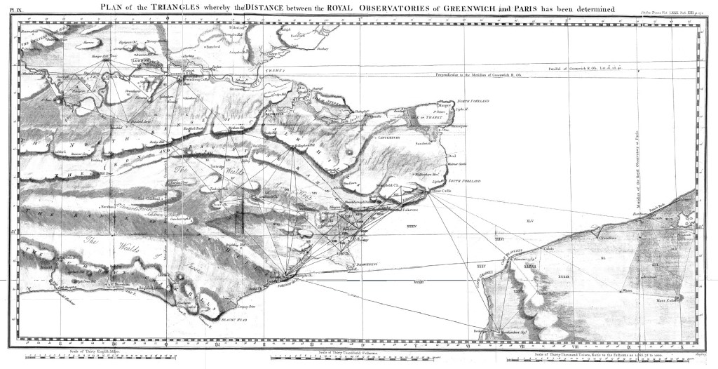
Image scanned from Close, 1926.
Thus, in 1787, British and French surveyors met at Dover and observed a chain of triangles across the English Channel, physically linking the two observatories. Through precise triangulation observed across southern England, William Roy connected Greenwich to the French stations. He derived a new value of 9 minutes 19 seconds of time, a difference of roughly 11 seconds of time, or about 2¾ arcminutes of longitude. This may sound small, but it was not. Eleven seconds of time at the latitude of Greenwich corresponds to approximately 3.2 kilometres on the ground, large enough to expose methodological limits but small enough to demonstrate that European geodesy had entered a new level of precision. Roy demonstrated that if the older astronomical value were correct, it would imply an implausible distortion in the Earth’s figure, and as his triangulation was internally consistent, he argued that the eclipse results were not. However, the immediate results were diplomatically inconclusive as no one could prove whether Greenwich or Paris was at fault. [3] Yet, a difference there was.
Modern geodesy provides the final arbiter. In contemporary satellite-based geodesy (WGS84), the Paris meridian lies 2° 20′ 14.025″ east of Greenwich, or 9 minutes 20.9 seconds of time. The comparison is striking:
- Cassini-era astronomical mean: ~9m 30s
- Roy’s triangulation: ~9m 19s
- Modern value: ~9m 20.9s
Roy’s result is within two seconds of the modern figure. The eclipse-based value was about nine seconds too large.
The significance lies not merely in the number, but in the method. Roy showed that, for neighbouring observatories, measured geometry on the Earth’s surface could outperform celestial timing. At sea, it was solved by chronometers, on land by triangulation. Thus, Longitude had become a geodetic challenge, not only an astronomical problem. In those eleven seconds lay a methodological turning point. It would also prove to be the intellectual foundation of what would become the Ordnance Survey.
British historians forgive the French their allegation, even its undiplomatic nature. It provided the perfect excuse for those wishing to put the country’s survey on a better footing, and the scientific consequences would be profound. Britain now possessed the instruments, techniques, and institutional confidence to extend triangulation across its territory. Once Britain possessed a measured geometric framework of its own territory, the question of whether Ireland should be included ceased to be theoretical and became unavoidable.
Making a Start
By the end of the eighteenth century, more accurate latitudes and longitudes in Great Britain and Ireland were required for several reasons. Many maps were notoriously inaccurate. Some County maps, dating from Elizabethan times, had errors of up to three miles in eighteen. Many were considered mere “artistic productions”, inferior to those of Bengal and inferior to the Carte de France of the Cassini family. [4] They were surveyed, at best, by compass directions and travel times, with sketched locations in between, the cartographer often relying on information from many often unreliable external sources, just as Ptolemy had fifteen hundred years earlier.
The problem of navigation and errors in available charts made the need for accurate positions around the coastlines particularly urgent. The notorious naval disaster of 1707, with the loss of up to two thousand sailors off the Scilly Islands, was partially due to navigation errors and uncharted reefs. [5] Whilst the Longitude Act 1714 established the Board of Longitude and prizes were aimed at encouraging a solution to the navigation challenge, [6] it was a simple fact that few maps or charts of Britain or Ireland had been based on accurate surveys. An accurate triangulation scheme across the islands would enable lighthouses, headlands and coastlines to be more accurately positioned, and provide the framework for more reliable maps.
The Paris–Greenwich triangulation demonstrated that large-scale, accurate measurement was possible, and that it could be organised by the state. After Roy died in 1790, the Board of Ordnance, under the Duke of Richmond, resolved to continue and expand the work. New instruments were commissioned, precise baselines were measured, and a permanent triangulation network began to spread across the country.
The Work Reaches Ireland
This triangulation, led first by Major Edward Williams and then by Lieutenant William Mudge, both from the Royal Artillery, progressed across Great Britain. In 1801, the first map, at a scale of one inch to the mile, was produced in Kent, a requirement that had arisen with the possibility of war following the French Revolution and the need for a trustworthy map of southern England. By the end of 1809, the triangulation had covered nearly the whole of England and Wales and, by 1823, had reached the southwest of Scotland from where the hills and mountains of Ireland, from the Mountains of Mourne to Malin Head, could be observed across the Irish Sea. [7]
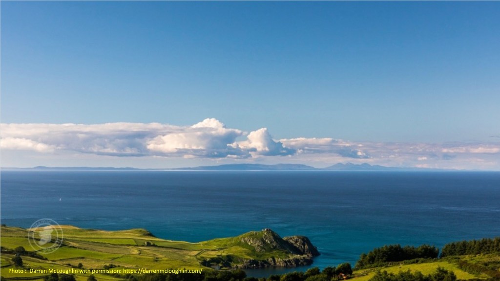
Photo : Darren McLoughlin with permission: https://darrenmcloughlin.com/
Pressure for an Irish survey was increasing from several directions. Militarily, Ireland remained a strategic concern in the aftermath of the 1798 rebellion. Administratively, land taxation depended on accurate areas, yet the size of townlands was often disputed. Ireland’s coasts needed to be mapped accurately within a scientifically consistent European measurement system that a triangulation scheme could provide.
The scene was now set for what would become the Principal Triangulation of Great Britain and Ireland, extending from the Scilly Isles through Land’s End to John O’Groats and beyond, to the northern reaches of the Shetland Islands at Saxavord on Unst. It would stretch to the western edges of Europe at Feaghmaan on Valentia Island; north to Malin Head in Donegal, and even farther north to Ben Mhor in the Western Isles. When complete, it would connect Ireland geographically to Britain and Europe and philosophically beyond the Enlightenment in a tradition of scientific exactness that stretched back to Ptolemy and the Ancient Greeks.
But first, the politics had to be addressed.
[1] The full memo is quoted in “The Early Years of the Ordnance Survey”, Colonel Sir Charles Close, Institution of Royal Engineers, 1926.
[2] “Ordnance Survey: Mapmaker to Britain since 1791” Tim Owen and Elaine Pillbeam, Ordnance Survey, 1992
[3] The latitude difference was also significantly in error by 12 seconds of arc per degree. When remeasured in 1821-23, as part of the West European Arc of the meridian, the difference was found to be 2o20’10”, compared to Roy’s 2o19’42”. (From“A History of the Ordnance Survey” Edited by W.A. Seymour, Dawson1980, p36 and p42.)
[4] Sir Joseph Banks, celebrated naturalist on Cook’s voyages, and President of the Royal Society, criticised the maps of England available in 1791. He compared the English maps unfavourably with those carried out by Major James Rennell, Surveyor General of Bengal, from 1764 to 1777. See “A history of the Ordnance Survey” Ed. W.A. Seymour, Dawson, 1980, p1.
[5] See previous Blog “The Scilly Isles” – the Scilly Isles were wrong by 26 minutes 37 seconds, nearly 32 kms – as noted by Charles Close, “The early Years of the Ordnance Survey”, p 43.
[6] Leading to John Harrison creating his celebrated chronometer – “Longitude: The True Story of a Lone Genius Who Solved the Greatest Scientific Problem of His Time”, Dava Sobel, Fourth Estate London 1998.
[7] In 1822-23: Close, p107.
By subscribing, you will be notified of new posts.

Response
[…] unknown; then disputes over the exact positions of the Paris and Greenwich Observatories, “La différence“, showed how position could be fixed by precise measurement; and finally, “A Complete […]
LikeLike